Boureni geodata
Boureni (Iaşi) is a populated place; located in Romania in Europe/Bucharest (GMT+3) time zone. With population of 1,425 people, there are 3297 cities with bigger population in this country. Compared to other cities in Romania, 85.8% of cities are located further ↓South; 82.5% of cities are located further ←West and 68.1% of cities have higher elevation than Boureni. Note1


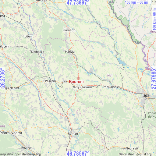
Boureni GPS coordinates[2]
47° 15' 53.892" North, 26° 58' 36.192" East
| Map corner | latitude | longitude |
|---|---|---|
| Upper-left | 47.73997°, | 26.2736° |
| Center: | 47.26497°, | 26.97672° |
| Lower-right: | 46.78567°, | 27.67985° |
| Map W x H: | 106.1×106.1 km | = 65.9×65.9mi |
| max Lat: | 48.23793° ⇑14.2% North |
| Boureni: | 47.26497° |
| min Lat: | ⇓85.8% South 43.65638° |
| min Long | Boureni | max Long |
| 20.31667° | 26.97672° | 29.65403° |
| W 82.5%⇐ | ⇒17.5% E |
Elevation
Elevation of Boureni is 134 m = 440 ft, and this is 120.9 m = 397 ft below average elevation for this country.
| Max E: |
1278 m = 4193 ft | 68.1% |
| Avg. | 254.9 m = 836 ft | |
| Boureni | 134 m = 440 ft | |
Min E: |
-2 m = -7 ft | 31.9% |
See also: Romania elevation on elevation.city.
Geographical zone
Boureni is located in North temperate zone (between Tropic of Cancer and the Arctic Circle). Distance of this North polar circle is 2145.8 km =1333.3 mi to North.| Distance of | km | miles | from Boureni |
|---|---|---|---|
| North Pole | 4751.7 | 2952.6 | to North |
| Arctic Circle | 2145.8 | 1333.3 | to North |
| Tropic Cancer | 2649.5 | 1646.3 | to South |
| Equator | 5255.4 | 3265.6 | to South |


Nearby cities:
15 places around Boureni: (largest is in red/bold)
• Balș
3.5 km =2.2 mi,  2°
2°
• Belceşti
8.9 km =5.5 mi,  64°
64°
• Buznea
8.3 km =5.2 mi,  159°
159°
• Costești
5.1 km =3.2 mi,  228°
228°
• Cucuteni
3.9 km =2.4 mi,  301°
301°
• Giurgești
5.4 km =3.4 mi,  252°
252°
• Hodora
8.7 km =5.4 mi,  21°
21°
• Ion Neculce
8.9 km =5.5 mi,  140°
140°
• Liteni
6.2 km =3.9 mi,  48°
48°
• Prigoreni
9.4 km =5.8 mi,  132°
132°
• Rediu
8.9 km =5.5 mi, 252°
• Războieni
7.7 km =4.8 mi, 133°
• Tansa
8.5 km =5.3 mi, 61°
• Târgu Frumos
7.4 km =4.6 mi,  166°
166°
• Ulmi
7.4 km =4.6 mi,  73°
73°
Sources, notices
• [Note1] Compared only with cities in Romania existing in our database
• [Src1] Map data: © OpenStreetMap contributors (CC-BY-SA)
• [Src2] Other city data from geonames.org with taken over terms of usage.
• [Src3] Geographical zone / Annual Mean Temperature by Robert A. Rohde @ Wikipedia
