Răuceşti geodata
Răuceşti (Neamţ) is a seat of a second-order administrative division; located in Romania in Europe/Bucharest (GMT+3) time zone. With population of 8,204 people, there are 295 cities with bigger population in this country. Compared to other cities in Romania, 85.3% of cities are located further ↓South; 71% of cities are located further ←West and 70.7% of cities have lower elevation than Răuceşti. Note1


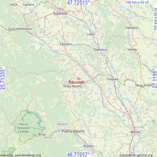
Răuceşti GPS coordinates[2]
47° 15' 0" North, 26° 25' 0.012" East
| Map corner | latitude | longitude |
|---|---|---|
| Upper-left | 47.72513°, | 25.71355° |
| Center: | 47.25°, | 26.41667° |
| Lower-right: | 46.77057°, | 27.1198° |
| Map W x H: | 106.1×106.1 km | = 65.9×65.9mi |
| max Lat: | 48.23793° ⇑14.7% North |
| Răuceşti: | 47.25° |
| min Lat: | ⇓85.3% South 43.65638° |
| min Long | Răuceşti | max Long |
| 20.31667° | 26.41667° | 29.65403° |
| W 71%⇐ | ⇒29% E |
Elevation
Elevation of Răuceşti is 326 m = 1070 ft, and this is 71.1 m = 233 ft above average elevation for this country.
| Max E: |
1278 m = 4193 ft | 29.3% |
| Răuceşti | 326 m 1070 ft | |
| Avg. | 254.9 m = 836 ft | |
Min E: |
-2 m = -7 ft | 70.7% |
See also: Romania elevation on elevation.city.
Geographical zone
Răuceşti is located in North temperate zone (between Tropic of Cancer and the Arctic Circle). Distance of this North polar circle is 2147.5 km =1334.4 mi to North.| Distance of | km | miles | from Răuceşti |
|---|---|---|---|
| North Pole | 4753.4 | 2953.6 | to North |
| Arctic Circle | 2147.5 | 1334.4 | to North |
| Tropic Cancer | 2647.8 | 1645.3 | to South |
| Equator | 5253.7 | 3264.5 | to South |


Nearby cities:
15 places around Răuceşti: (largest is in red/bold)
• Blebea
5.9 km =3.7 mi,  186°
186°
• Boiștea
8.2 km =5.1 mi,  173°
173°
• Brusturi
4.5 km =2.8 mi,  325°
325°
• Drăguşeni
6.2 km =3.9 mi,  53°
53°
• Drăgănești
6.6 km =4.1 mi,  352°
352°
• Dumbrava
5.1 km =3.2 mi,  136°
136°
• Humulești
7.5 km =4.7 mi,  220°
220°
• Oglinzi
5 km =3.1 mi,  270°
270°
• Oniceni
9 km =5.6 mi,  22°
22°
• Plăieșu
6.6 km =4.1 mi,  106°
106°
• Poiana
6.8 km =4.2 mi,  321°
321°
• Preutești
7.4 km =4.6 mi,  84°
84°
• Târgu Neamţ
6.7 km =4.2 mi,  214°
214°
• Târzia
8.3 km =5.2 mi, 328°
• Ungheni
3.6 km =2.2 mi,  63°
63°
Sources, notices
• [Note1] Compared only with cities in Romania existing in our database
• [Src1] Map data: © OpenStreetMap contributors (CC-BY-SA)
• [Src2] Other city data from geonames.org with taken over terms of usage.
• [Src3] Geographical zone / Annual Mean Temperature by Robert A. Rohde @ Wikipedia
