Preutești geodata
Preutești (Neamţ) is a populated place; located in Romania in Europe/Bucharest (GMT+3) time zone. With population of 588 people, there are 6301 cities with bigger population in this country. Compared to other cities in Romania, 85.6% of cities are located further ↓South; 72.8% of cities are located further ←West and 63.8% of cities have lower elevation than Preutești. Note1


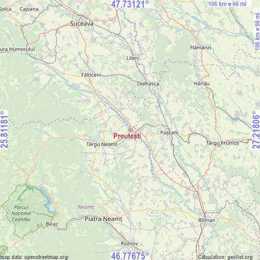
Preutești GPS coordinates[2]
47° 15' 22.068" North, 26° 30' 53.748" East
| Map corner | latitude | longitude |
|---|---|---|
| Upper-left | 47.73121°, | 25.81181° |
| Center: | 47.25613°, | 26.51493° |
| Lower-right: | 46.77675°, | 27.21806° |
| Map W x H: | 106.1×106.1 km | = 65.9×65.9mi |
| max Lat: | 48.23793° ⇑14.4% North |
| Preutești: | 47.25613° |
| min Lat: | ⇓85.6% South 43.65638° |
| min Long | Preutești | max Long |
| 20.31667° | 26.51493° | 29.65403° |
| W 72.8%⇐ | ⇒27.2% E |
Elevation
Elevation of Preutești is 283 m = 928 ft, and this is 28.1 m = 92 ft above average elevation for this country.
| Max E: |
1278 m = 4193 ft | 36.2% |
| Preutești | 283 m 928 ft | |
| Avg. | 254.9 m = 836 ft | |
Min E: |
-2 m = -7 ft | 63.8% |
See also: Romania elevation on elevation.city.
Geographical zone
Preutești is located in North temperate zone (between Tropic of Cancer and the Arctic Circle). Distance of this North polar circle is 2146.8 km =1334 mi to North.| Distance of | km | miles | from Preutești |
|---|---|---|---|
| North Pole | 4752.7 | 2953.2 | to North |
| Arctic Circle | 2146.8 | 1334 | to North |
| Tropic Cancer | 2648.5 | 1645.7 | to South |
| Equator | 5254.4 | 3264.9 | to South |


Nearby cities:
15 places around Preutești: (largest is in red/bold)
• Boureni
10 km =6.2 mi,  118°
118°
• Broșteni
6.2 km =3.9 mi,  30°
30°
• Cristeşti
4.1 km =2.5 mi,  73°
73°
• Drăguşeni
3.9 km =2.4 mi,  321°
321°
• Drăgănești
10.1 km =6.3 mi,  305°
305°
• Dumbrava
5.9 km =3.7 mi,  221°
221°
• Ingărești
8.8 km =5.5 mi,  168°
168°
• Moţca
7.7 km =4.8 mi,  95°
95°
• Oniceni
8.6 km =5.3 mi,  332°
332°
• Plăieșu
2.8 km =1.7 mi,  203°
203°
• Răuceşti
7.4 km =4.6 mi,  264°
264°
• Timişeşti
3.7 km =2.3 mi,  133°
133°
• Uda
9.9 km =6.2 mi, 25°
• Ungheni
4.3 km =2.7 mi,  282°
282°
• Urecheni
9.9 km =6.2 mi,  179°
179°
Sources, notices
• [Note1] Compared only with cities in Romania existing in our database
• [Src1] Map data: © OpenStreetMap contributors (CC-BY-SA)
• [Src2] Other city data from geonames.org with taken over terms of usage.
• [Src3] Geographical zone / Annual Mean Temperature by Robert A. Rohde @ Wikipedia
