Glodeni geodata
Glodeni (Dâmboviţa) is a section of populated place; located in Romania in Europe/Bucharest (GMT+3) time zone. With population of 1,187 people, there are 3776 cities with bigger population in this country. Compared to other cities in Romania, 67.2% of cities are located further ↑North; 53.9% of cities are located further ←West and 82% of cities have lower elevation than Glodeni. Note1


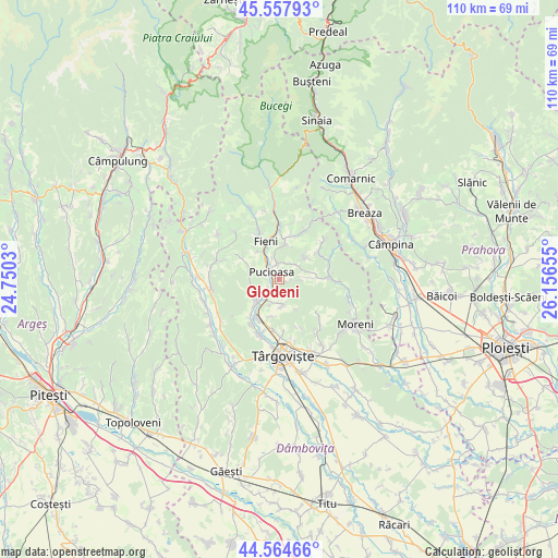
Glodeni GPS coordinates[2]
45° 3' 48.42" North, 25° 27' 12.312" East
| Map corner | latitude | longitude |
|---|---|---|
| Upper-left | 45.55793°, | 24.7503° |
| Center: | 45.06345°, | 25.45342° |
| Lower-right: | 44.56466°, | 26.15655° |
| Map W x H: | 110.4×110.4 km | = 68.6×68.6mi |
| max Lat: | 48.23793° ⇑67.2% North |
| Glodeni: | 45.06345° |
| min Lat: | ⇓32.8% South 43.65638° |
| min Long | Glodeni | max Long |
| 20.31667° | 25.45342° | 29.65403° |
| W 53.9%⇐ | ⇒46.1% E |
Elevation
Elevation of Glodeni is 412 m = 1352 ft, and this is 157.1 m = 515 ft above average elevation for this country.
| Max E: |
1278 m = 4193 ft | 18% |
| Glodeni | 412 m 1352 ft | |
| Avg. | 254.9 m = 836 ft | |
Min E: |
-2 m = -7 ft | 82% |
See also: Romania elevation on elevation.city.
Geographical zone
Glodeni is located in North temperate zone (between Tropic of Cancer and the Arctic Circle). Distance of this North polar circle is 2390.6 km =1485.4 mi to North.| Distance of | km | miles | from Glodeni |
|---|---|---|---|
| North Pole | 4996.5 | 3104.7 | to North |
| Arctic Circle | 2390.6 | 1485.4 | to North |
| Tropic Cancer | 2404.7 | 1494.2 | to South |
| Equator | 5010.6 | 3113.4 | to South |


Nearby cities:
15 places around Glodeni: (largest is in red/bold)
• Bela
4.3 km =2.7 mi,  340°
340°
• Brăneşti
4.4 km =2.7 mi,  220°
220°
• Diaconești
3.3 km =2.1 mi,  0°
0°
• Glodeni
5.3 km =3.3 mi,  168°
168°
• Gura Vulcanei
6.3 km =3.9 mi,  226°
226°
• Gușoiu
5.2 km =3.2 mi,  182°
182°
• Lăculețe
5.3 km =3.3 mi,  199°
199°
• Moțăieni
5 km =3.1 mi,  324°
324°
• Priboiu
4.7 km =2.9 mi,  210°
210°
• Pucioasa
2.3 km =1.4 mi,  314°
314°
• Schela
4.1 km =2.5 mi,  154°
154°
• Toculești
5.8 km =3.6 mi, 230°
• Vulcana Băi
5.9 km =3.7 mi,  288°
288°
• Vârfuri
6.4 km =4 mi,  50°
50°
• Ștubeie Tisa
5.2 km =3.2 mi,  85°
85°
Sources, notices
• [Note1] Compared only with cities in Romania existing in our database
• [Src1] Map data: © OpenStreetMap contributors (CC-BY-SA)
• [Src2] Other city data from geonames.org with taken over terms of usage.
• [Src3] Geographical zone / Annual Mean Temperature by Robert A. Rohde @ Wikipedia
