Produleşti geodata
Produleşti (Dâmboviţa) is a seat of a second-order administrative division; located in Romania in Europe/Bucharest (GMT+3) time zone. With population of 3,546 people, there are 1401 cities with bigger population in this country. Compared to other cities in Romania, 80.1% of cities are located further ↑North; 54.5% of cities are located further ←West and 58.3% of cities have higher elevation than Produleşti. Note1


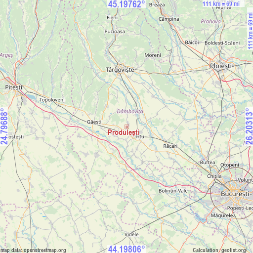
Produleşti GPS coordinates[2]
44° 42' 0" North, 25° 30' 0" East
| Map corner | latitude | longitude |
|---|---|---|
| Upper-left | 45.19762°, | 24.79688° |
| Center: | 44.7°, | 25.5° |
| Lower-right: | 44.19806°, | 26.20313° |
| Map W x H: | 111.1×111.1 km | = 69×69mi |
| max Lat: | 48.23793° ⇑80.1% North |
| Produleşti: | 44.7° |
| min Lat: | ⇓19.9% South 43.65638° |
| min Long | Produleşti | max Long |
| 20.31667° | 25.5° | 29.65403° |
| W 54.5%⇐ | ⇒45.5% E |
Elevation
Elevation of Produleşti is 172 m = 564 ft, and this is 82.9 m = 272 ft below average elevation for this country.
| Max E: |
1278 m = 4193 ft | 58.3% |
| Avg. | 254.9 m = 836 ft | |
| Produleşti | 172 m = 564 ft | |
Min E: |
-2 m = -7 ft | 41.7% |
See also: Romania elevation on elevation.city.
Geographical zone
Produleşti is located in North temperate zone (between Tropic of Cancer and the Arctic Circle). Distance of this Northern Tropic circle is 2364.3 km =1469.1 mi to South.| Distance of | km | miles | from Produleşti |
|---|---|---|---|
| North Pole | 5036.9 | 3129.8 | to North |
| Arctic Circle | 2431 | 1510.6 | to North |
| Tropic Cancer | 2364.3 | 1469.1 | to South |
| Equator | 4970.2 | 3088.3 | to South |


Nearby cities:
15 places around Produleşti: (largest is in red/bold)
• Broșteni
2.4 km =1.5 mi,  17°
17°
• Costeştii din Vale
5.7 km =3.5 mi,  193°
193°
• Costeștii din Deal
2.2 km =1.4 mi,  202°
202°
• Dâmbovicioara
5 km =3.1 mi,  122°
122°
• Fusea
5 km =3.1 mi,  147°
147°
• Gura Şuţii
5.7 km =3.5 mi,  13°
13°
• Hagioaica
4.8 km =3 mi,  137°
137°
• Odaia Turcului
3.9 km =2.4 mi,  266°
266°
• Plopu
5.9 km =3.7 mi,  158°
158°
• Podu Rizii
6.6 km =4.1 mi,  83°
83°
• Poroinica
5.9 km =3.7 mi,  225°
225°
• Puțu cu Salcie
6.3 km =3.9 mi,  212°
212°
• Tețcoiu
5.3 km =3.3 mi,  247°
247°
• Titu
6.2 km =3.9 mi, 154°
• Tomșani
6.5 km =4 mi,  178°
178°
Sources, notices
• [Note1] Compared only with cities in Romania existing in our database
• [Src1] Map data: © OpenStreetMap contributors (CC-BY-SA)
• [Src2] Other city data from geonames.org with taken over terms of usage.
• [Src3] Geographical zone / Annual Mean Temperature by Robert A. Rohde @ Wikipedia
