Fusea geodata
Fusea (Dâmboviţa) is a populated place; located in Romania in Europe/Bucharest (GMT+3) time zone. With population of 626 people, there are 6038 cities with bigger population in this country. Compared to other cities in Romania, 81.2% of cities are located further ↑North; 55% of cities are located further ←West and 62% of cities have higher elevation than Fusea. Note1


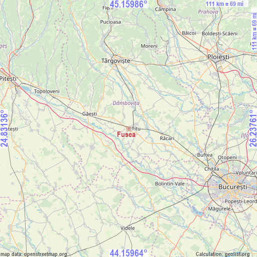
Fusea GPS coordinates[2]
44° 39' 42.876" North, 25° 32' 4.128" East
| Map corner | latitude | longitude |
|---|---|---|
| Upper-left | 45.15986°, | 24.83136° |
| Center: | 44.66191°, | 25.53448° |
| Lower-right: | 44.15964°, | 26.23761° |
| Map W x H: | 111.2×111.2 km | = 69.1×69.1mi |
| max Lat: | 48.23793° ⇑81.2% North |
| Fusea: | 44.66191° |
| min Lat: | ⇓18.8% South 43.65638° |
| min Long | Fusea | max Long |
| 20.31667° | 25.53448° | 29.65403° |
| W 55%⇐ | ⇒45% E |
Elevation
Elevation of Fusea is 159 m = 522 ft, and this is 95.9 m = 315 ft below average elevation for this country.
| Max E: |
1278 m = 4193 ft | 62% |
| Avg. | 254.9 m = 836 ft | |
| Fusea | 159 m = 522 ft | |
Min E: |
-2 m = -7 ft | 38% |
See also: Romania elevation on elevation.city.
Geographical zone
Fusea is located in North temperate zone (between Tropic of Cancer and the Arctic Circle). Distance of this Northern Tropic circle is 2360 km =1466.4 mi to South.| Distance of | km | miles | from Fusea |
|---|---|---|---|
| North Pole | 5041.1 | 3132.4 | to North |
| Arctic Circle | 2435.2 | 1513.2 | to North |
| Tropic Cancer | 2360 | 1466.4 | to South |
| Equator | 4965.9 | 3085.7 | to South |


Nearby cities:
15 places around Fusea: (largest is in red/bold)
• Braniştea
4.5 km =2.8 mi,  58°
58°
• Brâncoveanu
6 km =3.7 mi,  177°
177°
• Costeştii din Vale
4.3 km =2.7 mi,  251°
251°
• Costeștii din Deal
4.2 km =2.6 mi,  301°
301°
• Dâmbovicioara
2.2 km =1.4 mi,  44°
44°
• Hagioaica
0.9 km =0.6 mi, 35°
• Mărunțișu
4.4 km =2.7 mi,  209°
209°
• Odobeşti
5.6 km =3.5 mi,  153°
153°
• Plopu
1.4 km =0.9 mi, 206°
• Podu Rizii
6.3 km =3.9 mi, 37°
• Produleşti
5 km =3.1 mi,  327°
327°
• Puțu cu Salcie
6.2 km =3.9 mi,  260°
260°
• Sălcuța
4.2 km =2.6 mi,  118°
118°
• Titu
1.3 km =0.8 mi, 183°
• Tomșani
3.4 km =2.1 mi,  228°
228°
Sources, notices
• [Note1] Compared only with cities in Romania existing in our database
• [Src1] Map data: © OpenStreetMap contributors (CC-BY-SA)
• [Src2] Other city data from geonames.org with taken over terms of usage.
• [Src3] Geographical zone / Annual Mean Temperature by Robert A. Rohde @ Wikipedia
