Hagioaica geodata
Hagioaica (Dâmboviţa) is a populated place; located in Romania in Europe/Bucharest (GMT+3) time zone. With population of 559 people, there are 6514 cities with bigger population in this country. Compared to other cities in Romania, 80.9% of cities are located further ↑North; 55.1% of cities are located further ←West and 61.7% of cities have higher elevation than Hagioaica. Note1


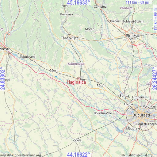
Hagioaica GPS coordinates[2]
44° 40' 6.348" North, 25° 32' 28.104" East
| Map corner | latitude | longitude |
|---|---|---|
| Upper-left | 45.16633°, | 24.83802° |
| Center: | 44.66843°, | 25.54114° |
| Lower-right: | 44.16622°, | 26.24427° |
| Map W x H: | 111.2×111.2 km | = 69.1×69.1mi |
| max Lat: | 48.23793° ⇑80.9% North |
| Hagioaica: | 44.66843° |
| min Lat: | ⇓19.1% South 43.65638° |
| min Long | Hagioaica | max Long |
| 20.31667° | 25.54114° | 29.65403° |
| W 55.1%⇐ | ⇒44.9% E |
Elevation
Elevation of Hagioaica is 160 m = 525 ft, and this is 94.9 m = 311 ft below average elevation for this country.
| Max E: |
1278 m = 4193 ft | 61.7% |
| Avg. | 254.9 m = 836 ft | |
| Hagioaica | 160 m = 525 ft | |
Min E: |
-2 m = -7 ft | 38.3% |
See also: Romania elevation on elevation.city.
Geographical zone
Hagioaica is located in North temperate zone (between Tropic of Cancer and the Arctic Circle). Distance of this Northern Tropic circle is 2360.7 km =1466.9 mi to South.| Distance of | km | miles | from Hagioaica |
|---|---|---|---|
| North Pole | 5040.4 | 3132 | to North |
| Arctic Circle | 2434.5 | 1512.7 | to North |
| Tropic Cancer | 2360.7 | 1466.9 | to South |
| Equator | 4966.7 | 3086.2 | to South |


Nearby cities:
15 places around Hagioaica: (largest is in red/bold)
• Braniştea
3.7 km =2.3 mi,  63°
63°
• Broșteni
6.3 km =3.9 mi,  336°
336°
• Costeştii din Vale
5 km =3.1 mi,  245°
245°
• Costeștii din Deal
4.3 km =2.7 mi,  289°
289°
• Dâmbovicioara
1.3 km =0.8 mi,  50°
50°
• Fusea
0.9 km =0.6 mi,  215°
215°
• Mărunțișu
5.3 km =3.3 mi,  210°
210°
• Odobeşti
6.1 km =3.8 mi,  160°
160°
• Plopu
2.3 km =1.4 mi, 209°
• Podu Rizii
5.4 km =3.4 mi,  37°
37°
• Produleşti
4.8 km =3 mi,  317°
317°
• Sălcioara
6.3 km =3.9 mi,  31°
31°
• Sălcuța
4.2 km =2.6 mi,  131°
131°
• Titu
2.1 km =1.3 mi,  196°
196°
• Tomșani
4.3 km =2.7 mi,  225°
225°
Sources, notices
• [Note1] Compared only with cities in Romania existing in our database
• [Src1] Map data: © OpenStreetMap contributors (CC-BY-SA)
• [Src2] Other city data from geonames.org with taken over terms of usage.
• [Src3] Geographical zone / Annual Mean Temperature by Robert A. Rohde @ Wikipedia
