Breasta geodata
Breasta (Dolj) is a seat of a second-order administrative division; located in Romania in Europe/Bucharest (GMT+3) time zone. With population of 3,867 people, there are 1217 cities with bigger population in this country. Compared to other cities in Romania, 90.1% of cities are located further ↑North; 74.5% of cities are located further →East and 70.6% of cities have higher elevation than Breasta. Note1


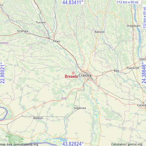
Breasta GPS coordinates[2]
44° 19' 59.988" North, 23° 40' 59.988" East
| Map corner | latitude | longitude |
|---|---|---|
| Upper-left | 44.83411°, | 22.98021° |
| Center: | 44.33333°, | 23.68333° |
| Lower-right: | 43.82824°, | 24.38646° |
| Map W x H: | 111.8×111.8 km | = 69.5×69.5mi |
| max Lat: | 48.23793° ⇑90.1% North |
| Breasta: | 44.33333° |
| min Lat: | ⇓9.9% South 43.65638° |
| min Long | Breasta | max Long |
| 20.31667° | 23.68333° | 29.65403° |
| W 25.5%⇐ | ⇒74.5% E |
Elevation
Elevation of Breasta is 125 m = 410 ft, and this is 129.9 m = 426 ft below average elevation for this country.
| Max E: |
1278 m = 4193 ft | 70.6% |
| Avg. | 254.9 m = 836 ft | |
| Breasta | 125 m = 410 ft | |
Min E: |
-2 m = -7 ft | 29.4% |
See also: Romania elevation on elevation.city.
Geographical zone
Breasta is located in North temperate zone (between Tropic of Cancer and the Arctic Circle). Distance of this Northern Tropic circle is 2323.5 km =1443.8 mi to South.| Distance of | km | miles | from Breasta |
|---|---|---|---|
| North Pole | 5077.7 | 3155.1 | to North |
| Arctic Circle | 2471.8 | 1535.9 | to North |
| Tropic Cancer | 2323.5 | 1443.8 | to South |
| Equator | 4929.4 | 3063 | to South |


Nearby cities:
15 places around Breasta: (largest is in red/bold)
• Albești
8.1 km =5 mi,  55°
55°
• Bucovăţ
6.5 km =4 mi,  124°
124°
• Cernele
4.6 km =2.9 mi,  89°
89°
• Cernelele de Sus
4.5 km =2.8 mi,  83°
83°
• Izvorul Rece
6.1 km =3.8 mi,  65°
65°
• Işalniţa
8.4 km =5.2 mi,  28°
28°
• Mihăița
6.7 km =4.2 mi,  347°
347°
• Mofleni
6.9 km =4.3 mi, 120°
• Palilula
7.8 km =4.8 mi,  157°
157°
• Popoveni
9.3 km =5.8 mi, 122°
• Potmelțu
9 km =5.6 mi,  343°
343°
• Predeşti
6.9 km =4.3 mi,  285°
285°
• Rovine
4.3 km =2.7 mi,  43°
43°
• Sărbătoarea
4.5 km =2.8 mi,  212°
212°
• Valea Lungului
2.4 km =1.5 mi,  327°
327°
Sources, notices
• [Note1] Compared only with cities in Romania existing in our database
• [Src1] Map data: © OpenStreetMap contributors (CC-BY-SA)
• [Src2] Other city data from geonames.org with taken over terms of usage.
• [Src3] Geographical zone / Annual Mean Temperature by Robert A. Rohde @ Wikipedia
