Vlăsceni geodata
Vlăsceni (Dâmboviţa) is a populated place; located in Romania in Europe/Bucharest (GMT+3) time zone. With population of 1,066 people, there are 4068 cities with bigger population in this country. Compared to other cities in Romania, 83.1% of cities are located further ↑North; 56.1% of cities are located further ←West and 67.7% of cities have higher elevation than Vlăsceni. Note1


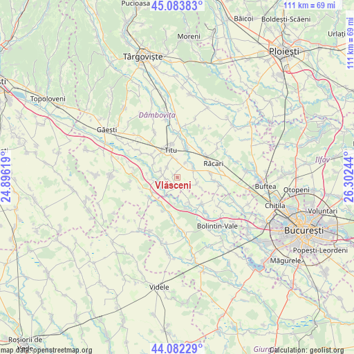
Vlăsceni GPS coordinates[2]
44° 35' 6.792" North, 25° 35' 57.516" East
| Map corner | latitude | longitude |
|---|---|---|
| Upper-left | 45.08383°, | 24.89619° |
| Center: | 44.58522°, | 25.59931° |
| Lower-right: | 44.08229°, | 26.30244° |
| Map W x H: | 111.4×111.4 km | = 69.2×69.2mi |
| max Lat: | 48.23793° ⇑83.1% North |
| Vlăsceni: | 44.58522° |
| min Lat: | ⇓16.9% South 43.65638° |
| min Long | Vlăsceni | max Long |
| 20.31667° | 25.59931° | 29.65403° |
| W 56.1%⇐ | ⇒43.9% E |
Elevation
Elevation of Vlăsceni is 136 m = 446 ft, and this is 118.9 m = 390 ft below average elevation for this country.
| Max E: |
1278 m = 4193 ft | 67.7% |
| Avg. | 254.9 m = 836 ft | |
| Vlăsceni | 136 m = 446 ft | |
Min E: |
-2 m = -7 ft | 32.3% |
See also: Romania elevation on elevation.city.
Geographical zone
Vlăsceni is located in North temperate zone (between Tropic of Cancer and the Arctic Circle). Distance of this Northern Tropic circle is 2351.5 km =1461.2 mi to South.| Distance of | km | miles | from Vlăsceni |
|---|---|---|---|
| North Pole | 5049.7 | 3137.7 | to North |
| Arctic Circle | 2443.8 | 1518.5 | to North |
| Tropic Cancer | 2351.5 | 1461.2 | to South |
| Equator | 4957.4 | 3080.4 | to South |


Nearby cities:
15 places around Vlăsceni: (largest is in red/bold)
• Brâncoveanu
5.5 km =3.4 mi,  297°
297°
• Crovu
5 km =3.1 mi,  275°
275°
• Cărpenișu
6.3 km =3.9 mi,  154°
154°
• Lunguleţu
5.3 km =3.3 mi,  48°
48°
• Miulești
6.9 km =4.3 mi, 284°
• Odobeşti
4.3 km =2.7 mi,  323°
323°
• Pitaru
1.3 km =0.8 mi, 296°
• Poiana
7 km =4.3 mi,  107°
107°
• Poiana lui Stângă
8.3 km =5.2 mi,  187°
187°
• Potlogi
4.1 km =2.5 mi,  197°
197°
• Românești
2.5 km =1.6 mi, 146°
• Serdanu
5.3 km =3.3 mi,  28°
28°
• Sălcuța
6.7 km =4.2 mi,  347°
347°
• Ungureni
7.9 km =4.9 mi,  264°
264°
• Zidurile
3.6 km =2.2 mi, 263°
Sources, notices
• [Note1] Compared only with cities in Romania existing in our database
• [Src1] Map data: © OpenStreetMap contributors (CC-BY-SA)
• [Src2] Other city data from geonames.org with taken over terms of usage.
• [Src3] Geographical zone / Annual Mean Temperature by Robert A. Rohde @ Wikipedia
