Poieni geodata
Poieni (Cluj) is a seat of a second-order administrative division; located in Romania in Europe/Bucharest (GMT+3) time zone. With population of 1,051 people, there are 4122 cities with bigger population in this country. Compared to other cities in Romania, 77% of cities are located further ↓South; 86.5% of cities are located further →East and 87.8% of cities have lower elevation than Poieni. Note1


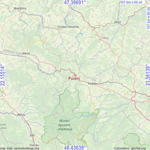
Poieni GPS coordinates[2]
46° 55' 7.68" North, 22° 51' 29.736" East
| Map corner | latitude | longitude |
|---|---|---|
| Upper-left | 47.39691°, | 22.15514° |
| Center: | 46.9188°, | 22.85826° |
| Lower-right: | 46.43639°, | 23.56139° |
| Map W x H: | 106.8×106.8 km | = 66.4×66.4mi |
| max Lat: | 48.23793° ⇑23% North |
| Poieni: | 46.9188° |
| min Lat: | ⇓77% South 43.65638° |
| min Long | Poieni | max Long |
| 20.31667° | 22.85826° | 29.65403° |
| W 13.5%⇐ | ⇒86.5% E |
Elevation
Elevation of Poieni is 479 m = 1572 ft, and this is 224.1 m = 735 ft above average elevation for this country.
| Max E: |
1278 m = 4193 ft | 12.2% |
| Poieni | 479 m 1572 ft | |
| Avg. | 254.9 m = 836 ft | |
Min E: |
-2 m = -7 ft | 87.8% |
See also: Romania elevation on elevation.city.
Geographical zone
Poieni is located in North temperate zone (between Tropic of Cancer and the Arctic Circle). Distance of this North polar circle is 2184.3 km =1357.3 mi to North.| Distance of | km | miles | from Poieni |
|---|---|---|---|
| North Pole | 4790.2 | 2976.5 | to North |
| Arctic Circle | 2184.3 | 1357.3 | to North |
| Tropic Cancer | 2611 | 1622.4 | to South |
| Equator | 5216.9 | 3241.6 | to South |


Nearby cities:
15 places around Poieni: (largest is in red/bold)
• Bicălatu
15.4 km =9.6 mi,  106°
106°
• Bucea
12.9 km =8 mi,  284°
284°
• Bulz
13.3 km =8.3 mi,  268°
268°
• Ciucea
4.7 km =2.9 mi,  317°
317°
• Fildu de Mijloc
10.5 km =6.5 mi,  87°
87°
• Fildu de Sus
8.2 km =5.1 mi,  78°
78°
• Hodișu
4.3 km =2.7 mi, 105°
• Munteni
13.2 km =8.2 mi,  249°
249°
• Negreni
8.2 km =5.1 mi,  298°
298°
• Pria
14.7 km =9.1 mi,  9°
9°
• Rogojel
13.9 km =8.6 mi,  179°
179°
• Sâncraiu
13.4 km =8.3 mi,  134°
134°
• Săcuieu
10.9 km =6.8 mi,  167°
167°
• Tusa
15.3 km =9.5 mi,  336°
336°
• Vânători
3.9 km =2.4 mi, 6°
Sources, notices
• [Note1] Compared only with cities in Romania existing in our database
• [Src1] Map data: © OpenStreetMap contributors (CC-BY-SA)
• [Src2] Other city data from geonames.org with taken over terms of usage.
• [Src3] Geographical zone / Annual Mean Temperature by Robert A. Rohde @ Wikipedia
