Ilfoveni geodata
Ilfoveni (Dâmboviţa) is a populated place; located in Romania in Europe/Bucharest (GMT+3) time zone. With population of 523 people, there are 6832 cities with bigger population in this country. Compared to other cities in Romania, 75.7% of cities are located further ↑North; 55.5% of cities are located further ←West and 52% of cities have lower elevation than Ilfoveni. Note1


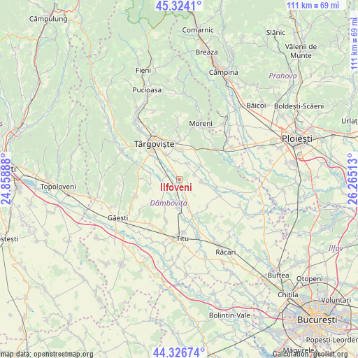
Ilfoveni GPS coordinates[2]
44° 49' 39.288" North, 25° 33' 43.2" East
| Map corner | latitude | longitude |
|---|---|---|
| Upper-left | 45.3241°, | 24.85888° |
| Center: | 44.82758°, | 25.562° |
| Lower-right: | 44.32674°, | 26.26513° |
| Map W x H: | 110.9×110.9 km | = 68.9×68.9mi |
| max Lat: | 48.23793° ⇑75.7% North |
| Ilfoveni: | 44.82758° |
| min Lat: | ⇓24.3% South 43.65638° |
| min Long | Ilfoveni | max Long |
| 20.31667° | 25.562° | 29.65403° |
| W 55.5%⇐ | ⇒44.5% E |
Elevation
Elevation of Ilfoveni is 222 m = 728 ft, and this is 32.9 m = 108 ft below average elevation for this country.
| Max E: |
1278 m = 4193 ft | 48% |
| Avg. | 254.9 m = 836 ft | |
| Ilfoveni | 222 m = 728 ft | |
Min E: |
-2 m = -7 ft | 52% |
See also: Romania elevation on elevation.city.
Geographical zone
Ilfoveni is located in North temperate zone (between Tropic of Cancer and the Arctic Circle). Distance of this Northern Tropic circle is 2378.4 km =1477.9 mi to South.| Distance of | km | miles | from Ilfoveni |
|---|---|---|---|
| North Pole | 5022.7 | 3121 | to North |
| Arctic Circle | 2416.8 | 1501.7 | to North |
| Tropic Cancer | 2378.4 | 1477.9 | to South |
| Equator | 4984.4 | 3097.2 | to South |


Nearby cities:
15 places around Ilfoveni: (largest is in red/bold)
• Brăteștii de Jos
2.3 km =1.4 mi,  251°
251°
• Bucşani
8.2 km =5.1 mi,  57°
57°
• Bungetu
2.6 km =1.6 mi,  312°
312°
• Băleni Sârbi
5.8 km =3.6 mi,  102°
102°
• Cazaci
3 km =1.9 mi,  192°
192°
• Comişani
6.4 km =4 mi,  15°
15°
• Ghinești
8.9 km =5.5 mi,  184°
184°
• Hăbeni
6.2 km =3.9 mi, 58°
• Lazuri
5.8 km =3.6 mi,  350°
350°
• Mircea Vodă
7.1 km =4.4 mi,  162°
162°
• Nucet
5 km =3.1 mi, 190°
• Perșinari
5.7 km =3.5 mi,  240°
240°
• Racovița
4.8 km =3 mi,  74°
74°
• Siliștea
9 km =5.6 mi, 251°
• Văcăreşti
6.7 km =4.2 mi,  291°
291°
Sources, notices
• [Note1] Compared only with cities in Romania existing in our database
• [Src1] Map data: © OpenStreetMap contributors (CC-BY-SA)
• [Src2] Other city data from geonames.org with taken over terms of usage.
• [Src3] Geographical zone / Annual Mean Temperature by Robert A. Rohde @ Wikipedia
