Ghinești geodata
Ghinești (Dâmboviţa) is a populated place; located in Romania in Europe/Bucharest (GMT+3) time zone. With population of 1,106 people, there are 3975 cities with bigger population in this country. Compared to other cities in Romania, 78.5% of cities are located further ↑North; 55.4% of cities are located further ←West and 54.8% of cities have higher elevation than Ghinești. Note1


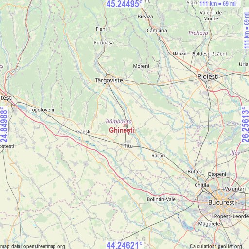
Ghinești GPS coordinates[2]
44° 44' 51.864" North, 25° 33' 10.8" East
| Map corner | latitude | longitude |
|---|---|---|
| Upper-left | 45.24495°, | 24.84988° |
| Center: | 44.74774°, | 25.553° |
| Lower-right: | 44.24621°, | 26.25613° |
| Map W x H: | 111×111 km | = 69×69mi |
| max Lat: | 48.23793° ⇑78.5% North |
| Ghinești: | 44.74774° |
| min Lat: | ⇓21.5% South 43.65638° |
| min Long | Ghinești | max Long |
| 20.31667° | 25.553° | 29.65403° |
| W 55.4%⇐ | ⇒44.6% E |
Elevation
Elevation of Ghinești is 188 m = 617 ft, and this is 66.9 m = 219 ft below average elevation for this country.
| Max E: |
1278 m = 4193 ft | 54.8% |
| Avg. | 254.9 m = 836 ft | |
| Ghinești | 188 m = 617 ft | |
Min E: |
-2 m = -7 ft | 45.2% |
See also: Romania elevation on elevation.city.
Geographical zone
Ghinești is located in North temperate zone (between Tropic of Cancer and the Arctic Circle). Distance of this Northern Tropic circle is 2369.6 km =1472.4 mi to South.| Distance of | km | miles | from Ghinești |
|---|---|---|---|
| North Pole | 5031.6 | 3126.5 | to North |
| Arctic Circle | 2425.7 | 1507.3 | to North |
| Tropic Cancer | 2369.6 | 1472.4 | to South |
| Equator | 4975.5 | 3091.6 | to South |


Nearby cities:
15 places around Ghinești: (largest is in red/bold)
• Bolovani
7 km =4.3 mi,  111°
111°
• Braniştea
7.6 km =4.7 mi,  161°
161°
• Broșteni
4.6 km =2.9 mi,  228°
228°
• Brăteștii de Jos
8.3 km =5.2 mi,  349°
349°
• Cazaci
6 km =3.7 mi,  0°
0°
• Dâmbovicioara
8 km =5 mi,  179°
179°
• Gura Şuţii
2.9 km =1.8 mi,  275°
275°
• Ilfoveni
8.9 km =5.5 mi, 4°
• Mircea Vodă
3.5 km =2.2 mi,  52°
52°
• Nucet
4 km =2.5 mi,  356°
356°
• Perșinari
7.4 km =4.6 mi,  324°
324°
• Podu Rizii
5.1 km =3.2 mi,  152°
152°
• Produleşti
6.8 km =4.2 mi,  218°
218°
• Speriețeni
8.2 km =5.1 mi, 284°
• Sălcioara
4.2 km =2.6 mi, 145°
Sources, notices
• [Note1] Compared only with cities in Romania existing in our database
• [Src1] Map data: © OpenStreetMap contributors (CC-BY-SA)
• [Src2] Other city data from geonames.org with taken over terms of usage.
• [Src3] Geographical zone / Annual Mean Temperature by Robert A. Rohde @ Wikipedia
