Păcioiu geodata
Păcioiu (Arges) is a populated place; located in Romania in Europe/Bucharest (GMT+3) time zone. With population of 724 people, there are 5440 cities with bigger population in this country. Compared to other cities in Romania, 66.4% of cities are located further ↑North; 54.6% of cities are located further →East and 81.3% of cities have lower elevation than Păcioiu. Note1


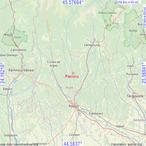
Păcioiu GPS coordinates[2]
45° 4' 56.388" North, 24° 51' 55.008" East
| Map corner | latitude | longitude |
|---|---|---|
| Upper-left | 45.57664°, | 24.16216° |
| Center: | 45.08233°, | 24.86528° |
| Lower-right: | 44.5837°, | 25.56841° |
| Map W x H: | 110.4×110.4 km | = 68.6×68.6mi |
| max Lat: | 48.23793° ⇑66.4% North |
| Păcioiu: | 45.08233° |
| min Lat: | ⇓33.6% South 43.65638° |
| min Long | Păcioiu | max Long |
| 20.31667° | 24.86528° | 29.65403° |
| W 45.4%⇐ | ⇒54.6% E |
Elevation
Elevation of Păcioiu is 406 m = 1332 ft, and this is 151.1 m = 496 ft above average elevation for this country.
| Max E: |
1278 m = 4193 ft | 18.7% |
| Păcioiu | 406 m 1332 ft | |
| Avg. | 254.9 m = 836 ft | |
Min E: |
-2 m = -7 ft | 81.3% |
See also: Romania elevation on elevation.city.
Geographical zone
Păcioiu is located in North temperate zone (between Tropic of Cancer and the Arctic Circle). Distance of this North polar circle is 2388.5 km =1484.1 mi to North.| Distance of | km | miles | from Păcioiu |
|---|---|---|---|
| North Pole | 4994.4 | 3103.4 | to North |
| Arctic Circle | 2388.5 | 1484.1 | to North |
| Tropic Cancer | 2406.8 | 1495.5 | to South |
| Equator | 5012.7 | 3114.7 | to South |


Nearby cities:
15 places around Păcioiu: (largest is in red/bold)
• Budeasa
7.4 km =4.6 mi,  189°
189°
• Bălileşti
5.6 km =3.5 mi,  108°
108°
• Coşeşti
1.7 km =1.1 mi,  176°
176°
• Dărmăneşti
7.8 km =4.8 mi,  159°
159°
• Gănești
4.8 km =3 mi,  336°
336°
• Jupânești
2.1 km =1.3 mi,  214°
214°
• Leicești
1.5 km =0.9 mi,  347°
347°
• Mălureni
5.5 km =3.4 mi,  290°
290°
• Petrești
4.7 km =2.9 mi, 155°
• Poienița
5.9 km =3.7 mi,  56°
56°
• Păuleasca
7.9 km =4.9 mi,  197°
197°
• Retevoiești
6.8 km =4.2 mi, 341°
• Stroești
7.7 km =4.8 mi,  313°
313°
• Valea Mare-Bratia
6.8 km =4.2 mi,  99°
99°
• Valea Nandrii
7.3 km =4.5 mi,  169°
169°
Sources, notices
• [Note1] Compared only with cities in Romania existing in our database
• [Src1] Map data: © OpenStreetMap contributors (CC-BY-SA)
• [Src2] Other city data from geonames.org with taken over terms of usage.
• [Src3] Geographical zone / Annual Mean Temperature by Robert A. Rohde @ Wikipedia
