Gănești geodata
Gănești (Arges) is a populated place; located in Romania in Europe/Bucharest (GMT+3) time zone. With population of 737 people, there are 5354 cities with bigger population in this country. Compared to other cities in Romania, 64.5% of cities are located further ↑North; 54.8% of cities are located further →East and 82.7% of cities have lower elevation than Gănești. Note1


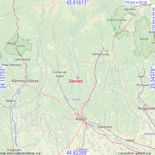
Gănești GPS coordinates[2]
45° 7' 19.776" North, 24° 50' 26.34" East
| Map corner | latitude | longitude |
|---|---|---|
| Upper-left | 45.61613°, | 24.13753° |
| Center: | 45.12216°, | 24.84065° |
| Lower-right: | 44.62388°, | 25.54378° |
| Map W x H: | 110.3×110.3 km | = 68.5×68.5mi |
| max Lat: | 48.23793° ⇑64.5% North |
| Gănești: | 45.12216° |
| min Lat: | ⇓35.5% South 43.65638° |
| min Long | Gănești | max Long |
| 20.31667° | 24.84065° | 29.65403° |
| W 45.2%⇐ | ⇒54.8% E |
Elevation
Elevation of Gănești is 420 m = 1378 ft, and this is 165.1 m = 542 ft above average elevation for this country.
| Max E: |
1278 m = 4193 ft | 17.3% |
| Gănești | 420 m 1378 ft | |
| Avg. | 254.9 m = 836 ft | |
Min E: |
-2 m = -7 ft | 82.7% |
See also: Romania elevation on elevation.city.
Geographical zone
Gănești is located in North temperate zone (between Tropic of Cancer and the Arctic Circle). Distance of this North polar circle is 2384.1 km =1481.4 mi to North.| Distance of | km | miles | from Gănești |
|---|---|---|---|
| North Pole | 4989.9 | 3100.6 | to North |
| Arctic Circle | 2384.1 | 1481.4 | to North |
| Tropic Cancer | 2411.2 | 1498.2 | to South |
| Equator | 5017.1 | 3117.5 | to South |


Nearby cities:
15 places around Gănești: (largest is in red/bold)
• Bădești
5.7 km =3.5 mi,  15°
15°
• Bălileşti
9.5 km =5.9 mi,  130°
130°
• Coşeşti
6.5 km =4 mi,  161°
161°
• Domneşti
8.7 km =5.4 mi,  356°
356°
• Jupânești
6.2 km =3.9 mi,  173°
173°
• Leicești
3.3 km =2.1 mi,  151°
151°
• Mălureni
4 km =2.5 mi,  232°
232°
• Pietroşani
6.8 km =4.2 mi,  6°
6°
• Poienița
6.9 km =4.3 mi,  99°
99°
• Păcioiu
4.8 km =3 mi, 156°
• Retevoiești
2 km =1.2 mi,  354°
354°
• Stroești
3.7 km =2.3 mi,  282°
282°
• Toplița
9.2 km =5.7 mi,  247°
247°
• Valea Siliștii
9.2 km =5.7 mi,  34°
34°
• Vlădești
6.7 km =4.2 mi,  62°
62°
Sources, notices
• [Note1] Compared only with cities in Romania existing in our database
• [Src1] Map data: © OpenStreetMap contributors (CC-BY-SA)
• [Src2] Other city data from geonames.org with taken over terms of usage.
• [Src3] Geographical zone / Annual Mean Temperature by Robert A. Rohde @ Wikipedia
