Mălureni geodata
Mălureni (Arges) is a seat of a second-order administrative division; located in Romania in Europe/Bucharest (GMT+3) time zone. With population of 4,762 people, there are 853 cities with bigger population in this country. Compared to other cities in Romania, 65.6% of cities are located further ↑North; 55.5% of cities are located further →East and 81.2% of cities have lower elevation than Mălureni. Note1


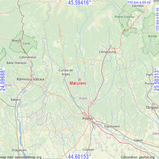
Mălureni GPS coordinates[2]
45° 6' 0" North, 24° 48' 0" East
| Map corner | latitude | longitude |
|---|---|---|
| Upper-left | 45.59416°, | 24.09688° |
| Center: | 45.1°, | 24.8° |
| Lower-right: | 44.60153°, | 25.50313° |
| Map W x H: | 110.4×110.4 km | = 68.6×68.6mi |
| max Lat: | 48.23793° ⇑65.6% North |
| Mălureni: | 45.1° |
| min Lat: | ⇓34.4% South 43.65638° |
| min Long | Mălureni | max Long |
| 20.31667° | 24.8° | 29.65403° |
| W 44.5%⇐ | ⇒55.5% E |
Elevation
Elevation of Mălureni is 404 m = 1325 ft, and this is 149.1 m = 489 ft above average elevation for this country.
| Max E: |
1278 m = 4193 ft | 18.8% |
| Mălureni | 404 m 1325 ft | |
| Avg. | 254.9 m = 836 ft | |
Min E: |
-2 m = -7 ft | 81.2% |
See also: Romania elevation on elevation.city.
Geographical zone
Mălureni is located in North temperate zone (between Tropic of Cancer and the Arctic Circle). Distance of this North polar circle is 2386.5 km =1482.9 mi to North.| Distance of | km | miles | from Mălureni |
|---|---|---|---|
| North Pole | 4992.4 | 3102.1 | to North |
| Arctic Circle | 2386.5 | 1482.9 | to North |
| Tropic Cancer | 2408.7 | 1496.7 | to South |
| Equator | 5014.6 | 3115.9 | to South |


Nearby cities:
15 places around Mălureni: (largest is in red/bold)
• Bunești
10 km =6.2 mi,  201°
201°
• Bădești
9.3 km =5.8 mi,  30°
30°
• Băiculeşti
8.7 km =5.4 mi,  244°
244°
• Coşeşti
6.4 km =4 mi,  125°
125°
• Gănești
4 km =2.5 mi,  52°
52°
• Jupânești
5.4 km =3.4 mi, 133°
• Leicești
4.8 km =3 mi,  95°
95°
• Petrești
9.4 km =5.8 mi, 131°
• Păcioiu
5.5 km =3.4 mi,  110°
110°
• Păuleasca
9.8 km =6.1 mi,  163°
163°
• Retevoiești
5.4 km =3.4 mi, 33°
• Stroești
3.3 km =2.1 mi,  352°
352°
• Toplița
5.4 km =3.4 mi,  258°
258°
• Zigoneni
9.5 km =5.9 mi, 264°
• Zărnești
9.2 km =5.7 mi,  194°
194°
Sources, notices
• [Note1] Compared only with cities in Romania existing in our database
• [Src1] Map data: © OpenStreetMap contributors (CC-BY-SA)
• [Src2] Other city data from geonames.org with taken over terms of usage.
• [Src3] Geographical zone / Annual Mean Temperature by Robert A. Rohde @ Wikipedia
