Comana geodata
Comana (Constanța) is a seat of a second-order administrative division; located in Romania in Europe/Bucharest (GMT+3) time zone. With population of 1,850 people, there are 2764 cities with bigger population in this country. Compared to other cities in Romania, 98.5% of cities are located further ↑North; 98.1% of cities are located further ←West and 80.2% of cities have higher elevation than Comana. Note1


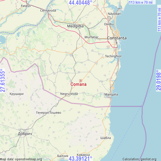
Comana GPS coordinates[2]
43° 54' 0" North, 28° 19' 0.012" East
| Map corner | latitude | longitude |
|---|---|---|
| Upper-left | 44.40448°, | 27.61355° |
| Center: | 43.9°, | 28.31667° |
| Lower-right: | 43.39121°, | 29.0198° |
| Map W x H: | 112.7×112.7 km | = 70×70mi |
| max Lat: | 48.23793° ⇑98.5% North |
| Comana: | 43.9° |
| min Lat: | ⇓1.5% South 43.65638° |
| min Long | Comana | max Long |
| 20.31667° | 28.31667° | 29.65403° |
| W 98.1%⇐ | ⇒1.9% E |
Elevation
Elevation of Comana is 94 m = 308 ft, and this is 160.9 m = 528 ft below average elevation for this country.
| Max E: |
1278 m = 4193 ft | 80.2% |
| Avg. | 254.9 m = 836 ft | |
| Comana | 94 m = 308 ft | |
Min E: |
-2 m = -7 ft | 19.8% |
See also: Romania elevation on elevation.city.
Geographical zone
Comana is located in North temperate zone (between Tropic of Cancer and the Arctic Circle). Distance of this Northern Tropic circle is 2275.3 km =1413.8 mi to South.| Distance of | km | miles | from Comana |
|---|---|---|---|
| North Pole | 5125.8 | 3185 | to North |
| Arctic Circle | 2520 | 1565.9 | to North |
| Tropic Cancer | 2275.3 | 1413.8 | to South |
| Equator | 4881.2 | 3033 | to South |


Nearby cities:
15 places around Comana: (largest is in red/bold)
• Albeşti
13.7 km =8.5 mi,  144°
144°
• Amzacea
8.7 km =5.4 mi,  50°
50°
• Arsa
13.7 km =8.5 mi,  119°
119°
• Chirnogeni
6.7 km =4.2 mi,  270°
270°
• Cotu Văii
8.9 km =5.5 mi,  164°
164°
• Darabani
12.6 km =7.8 mi,  187°
187°
• General Scărișoreanu
6.2 km =3.9 mi,  348°
348°
• Mereni
17.2 km =10.7 mi,  13°
13°
• Movila Verde
15.8 km =9.8 mi,  296°
296°
• Negru Vodă
13.2 km =8.2 mi,  225°
225°
• Osmancea
12.7 km =7.9 mi,  2°
2°
• Pecineaga
14.7 km =9.1 mi,  90°
90°
• Plopeni
11.3 km =7 mi, 300°
• Topraisar
16.8 km =10.4 mi,  39°
39°
• Tătaru
4.1 km =2.5 mi, 121°
Sources, notices
• [Note1] Compared only with cities in Romania existing in our database
• [Src1] Map data: © OpenStreetMap contributors (CC-BY-SA)
• [Src2] Other city data from geonames.org with taken over terms of usage.
• [Src3] Geographical zone / Annual Mean Temperature by Robert A. Rohde @ Wikipedia
