Orodel geodata
Orodel (Dolj) is a seat of a second-order administrative division; located in Romania in Europe/Bucharest (GMT+3) time zone. With population of 1,193 people, there are 3757 cities with bigger population in this country. Compared to other cities in Romania, 92.6% of cities are located further ↑North; 81.1% of cities are located further →East and 60.1% of cities have higher elevation than Orodel. Note1


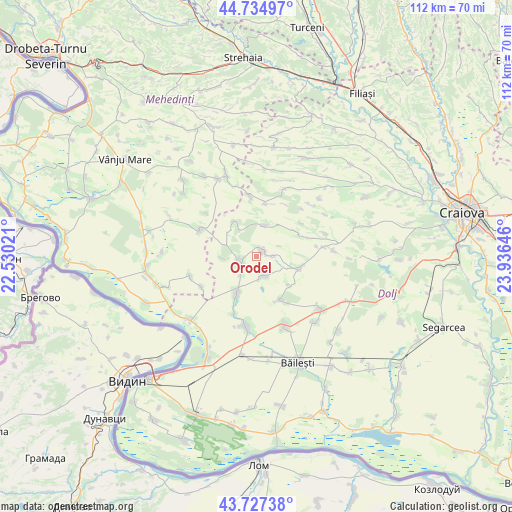
Orodel GPS coordinates[2]
44° 13' 59.988" North, 23° 13' 59.988" East
| Map corner | latitude | longitude |
|---|---|---|
| Upper-left | 44.73497°, | 22.53021° |
| Center: | 44.23333°, | 23.23333° |
| Lower-right: | 43.72738°, | 23.93646° |
| Map W x H: | 112×112 km | = 69.6×69.6mi |
| max Lat: | 48.23793° ⇑92.6% North |
| Orodel: | 44.23333° |
| min Lat: | ⇓7.4% South 43.65638° |
| min Long | Orodel | max Long |
| 20.31667° | 23.23333° | 29.65403° |
| W 18.9%⇐ | ⇒81.1% E |
Elevation
Elevation of Orodel is 166 m = 545 ft, and this is 88.9 m = 292 ft below average elevation for this country.
| Max E: |
1278 m = 4193 ft | 60.1% |
| Avg. | 254.9 m = 836 ft | |
| Orodel | 166 m = 545 ft | |
Min E: |
-2 m = -7 ft | 39.9% |
See also: Romania elevation on elevation.city.
Geographical zone
Orodel is located in North temperate zone (between Tropic of Cancer and the Arctic Circle). Distance of this Northern Tropic circle is 2312.4 km =1436.9 mi to South.| Distance of | km | miles | from Orodel |
|---|---|---|---|
| North Pole | 5088.8 | 3162 | to North |
| Arctic Circle | 2482.9 | 1542.8 | to North |
| Tropic Cancer | 2312.4 | 1436.9 | to South |
| Equator | 4918.3 | 3056.1 | to South |


Nearby cities:
15 places around Orodel: (largest is in red/bold)
• Bucovicior
12 km =7.5 mi,  52°
52°
• Caraula
5.7 km =3.5 mi,  166°
166°
• Carpen
11.2 km =7 mi,  6°
6°
• Castrele Traiane
7.5 km =4.7 mi,  266°
266°
• Cornu
3.4 km =2.1 mi,  88°
88°
• Călugărei
7 km =4.3 mi, 14°
• Domnu Tudor
12.4 km =7.7 mi,  146°
146°
• Gubaucea
10.3 km =6.4 mi,  59°
59°
• Izvoare
10.7 km =6.6 mi, 152°
• Oprişor
13.2 km =8.2 mi,  294°
294°
• Pleniţa
4.4 km =2.7 mi,  245°
245°
• Unirea
10.1 km =6.3 mi,  203°
203°
• Verbicioara
6.7 km =4.2 mi,  327°
327°
• Verbiţa
9.1 km =5.7 mi,  324°
324°
• Vârtop
9.7 km =6 mi,  107°
107°
Sources, notices
• [Note1] Compared only with cities in Romania existing in our database
• [Src1] Map data: © OpenStreetMap contributors (CC-BY-SA)
• [Src2] Other city data from geonames.org with taken over terms of usage.
• [Src3] Geographical zone / Annual Mean Temperature by Robert A. Rohde @ Wikipedia
