Neicu geodata
Neicu (Vrancea) is a section of populated place; located in Romania in Europe/Bucharest (GMT+3) time zone. With population of 646 people, there are 5901 cities with bigger population in this country. Compared to other cities in Romania, 53.3% of cities are located further ↓South; 84.6% of cities are located further ←West and 61.2% of cities have lower elevation than Neicu. Note1


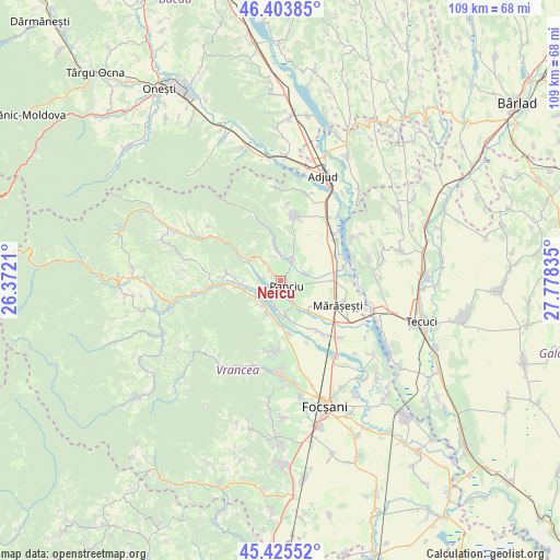
Neicu GPS coordinates[2]
45° 55' 0.624" North, 27° 4' 30.792" East
| Map corner | latitude | longitude |
|---|---|---|
| Upper-left | 46.40385°, | 26.3721° |
| Center: | 45.91684°, | 27.07522° |
| Lower-right: | 45.42552°, | 27.77835° |
| Map W x H: | 108.8×108.8 km | = 67.6×67.6mi |
| max Lat: | 48.23793° ⇑46.7% North |
| Neicu: | 45.91684° |
| min Lat: | ⇓53.3% South 43.65638° |
| min Long | Neicu | max Long |
| 20.31667° | 27.07522° | 29.65403° |
| W 84.6%⇐ | ⇒15.4% E |
Elevation
Elevation of Neicu is 270 m = 886 ft, and this is 15.1 m = 50 ft above average elevation for this country.
| Max E: |
1278 m = 4193 ft | 38.8% |
| Neicu | 270 m 886 ft | |
| Avg. | 254.9 m = 836 ft | |
Min E: |
-2 m = -7 ft | 61.2% |
See also: Romania elevation on elevation.city.
Geographical zone
Neicu is located in North temperate zone (between Tropic of Cancer and the Arctic Circle). Distance of this North polar circle is 2295.7 km =1426.5 mi to North.| Distance of | km | miles | from Neicu |
|---|---|---|---|
| North Pole | 4901.6 | 3045.7 | to North |
| Arctic Circle | 2295.7 | 1426.5 | to North |
| Tropic Cancer | 2499.6 | 1553.2 | to South |
| Equator | 5105.5 | 3172.4 | to South |


Nearby cities:
15 places around Neicu: (largest is in red/bold)
• Crucea de Sus
0.6 km =0.4 mi,  83°
83°
• Diocheți-Rediu
5.2 km =3.2 mi,  72°
72°
• Dumbrava
3 km =1.9 mi,  105°
105°
• Fitioneşti
7.6 km =4.7 mi,  345°
345°
• Găgești
6.9 km =4.3 mi,  192°
192°
• Moviliţa
4.2 km =2.6 mi,  27°
27°
• Muncelu
5.2 km =3.2 mi,  318°
318°
• Panciu
2 km =1.2 mi,  161°
161°
• Pietroasa
6.4 km =4 mi,  204°
204°
• Satu Nou
3.5 km =2.2 mi,  149°
149°
• Străoane
2.7 km =1.7 mi,  313°
313°
• Sârbi
5.3 km =3.3 mi, 188°
• Vitănești
4.6 km =2.9 mi,  217°
217°
• Vităneștii de Sub Măgură
6 km =3.7 mi, 218°
• Ţifeşti
7.7 km =4.8 mi,  165°
165°
Sources, notices
• [Note1] Compared only with cities in Romania existing in our database
• [Src1] Map data: © OpenStreetMap contributors (CC-BY-SA)
• [Src2] Other city data from geonames.org with taken over terms of usage.
• [Src3] Geographical zone / Annual Mean Temperature by Robert A. Rohde @ Wikipedia
