Negrești geodata
Negrești (Constanța) is a populated place; located in Romania in Europe/Bucharest (GMT+3) time zone. With population of 588 people, there are 6301 cities with bigger population in this country. Compared to other cities in Romania, 97% of cities are located further ↑North; 97.4% of cities are located further ←West and 86.5% of cities have higher elevation than Negrești. Note1


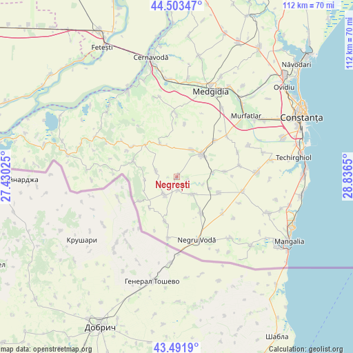
Negrești GPS coordinates[2]
43° 59' 59.424" North, 28° 8' 0.132" East
| Map corner | latitude | longitude |
|---|---|---|
| Upper-left | 44.50347°, | 27.43025° |
| Center: | 43.99984°, | 28.13337° |
| Lower-right: | 43.4919°, | 28.8365° |
| Map W x H: | 112.5×112.5 km | = 69.9×69.9mi |
| max Lat: | 48.23793° ⇑97% North |
| Negrești: | 43.99984° |
| min Lat: | ⇓3% South 43.65638° |
| min Long | Negrești | max Long |
| 20.31667° | 28.13337° | 29.65403° |
| W 97.4%⇐ | ⇒2.6% E |
Elevation
Elevation of Negrești is 73 m = 240 ft, and this is 181.9 m = 597 ft below average elevation for this country.
| Max E: |
1278 m = 4193 ft | 86.5% |
| Avg. | 254.9 m = 836 ft | |
| Negrești | 73 m = 240 ft | |
Min E: |
-2 m = -7 ft | 13.5% |
See also: Romania elevation on elevation.city.
Geographical zone
Negrești is located in North temperate zone (between Tropic of Cancer and the Arctic Circle). Distance of this Northern Tropic circle is 2286.4 km =1420.7 mi to South.| Distance of | km | miles | from Negrești |
|---|---|---|---|
| North Pole | 5114.7 | 3178.1 | to North |
| Arctic Circle | 2508.9 | 1559 | to North |
| Tropic Cancer | 2286.4 | 1420.7 | to South |
| Equator | 4892.3 | 3039.9 | to South |


Nearby cities:
15 places around Negrești: (largest is in red/bold)
• Chirnogeni
13.7 km =8.5 mi,  144°
144°
• Ciocârlia
16.4 km =10.2 mi,  47°
47°
• Cobadin
11.4 km =7.1 mi,  35°
35°
• Deleni
14.5 km =9 mi,  320°
320°
• Dumbrăveni
14.1 km =8.8 mi,  238°
238°
• General Scărișoreanu
14.3 km =8.9 mi,  110°
110°
• Independenţa
5.4 km =3.4 mi,  227°
227°
• Movila Verde
4.1 km =2.5 mi,  172°
172°
• Osmancea
15.3 km =9.5 mi,  83°
83°
• Petroșani
6.7 km =4.2 mi,  284°
284°
• Pietreni
11.9 km =7.4 mi,  334°
334°
• Plopeni
7.3 km =4.5 mi, 138°
• Viișoara
9.9 km =6.2 mi,  29°
29°
• Viroaga
14.7 km =9.1 mi,  194°
194°
• Șipotele
14.8 km =9.2 mi,  289°
289°
Sources, notices
• [Note1] Compared only with cities in Romania existing in our database
• [Src1] Map data: © OpenStreetMap contributors (CC-BY-SA)
• [Src2] Other city data from geonames.org with taken over terms of usage.
• [Src3] Geographical zone / Annual Mean Temperature by Robert A. Rohde @ Wikipedia
