Independenţa geodata
Independenţa (Constanța) is a seat of a second-order administrative division; located in Romania in Europe/Bucharest (GMT+3) time zone. With population of 3,145 people, there are 1659 cities with bigger population in this country. Compared to other cities in Romania, 97.4% of cities are located further ↑North; 97% of cities are located further ←West and 63% of cities have higher elevation than Independenţa. Note1


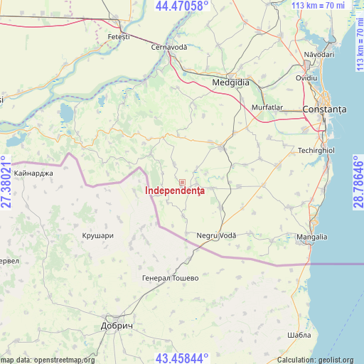
Independenţa GPS coordinates[2]
43° 58' 0.012" North, 28° 4' 59.988" East
| Map corner | latitude | longitude |
|---|---|---|
| Upper-left | 44.47058°, | 27.38021° |
| Center: | 43.96667°, | 28.08333° |
| Lower-right: | 43.45844°, | 28.78646° |
| Map W x H: | 112.5×112.5 km | = 69.9×69.9mi |
| max Lat: | 48.23793° ⇑97.4% North |
| Independenţa: | 43.96667° |
| min Lat: | ⇓2.6% South 43.65638° |
| min Long | Independenţa | max Long |
| 20.31667° | 28.08333° | 29.65403° |
| W 97%⇐ | ⇒3% E |
Elevation
Elevation of Independenţa is 155 m = 509 ft, and this is 99.9 m = 328 ft below average elevation for this country.
| Max E: |
1278 m = 4193 ft | 63% |
| Avg. | 254.9 m = 836 ft | |
| Independenţa | 155 m = 509 ft | |
Min E: |
-2 m = -7 ft | 37% |
See also: Romania elevation on elevation.city.
Geographical zone
Independenţa is located in North temperate zone (between Tropic of Cancer and the Arctic Circle). Distance of this Northern Tropic circle is 2282.7 km =1418.4 mi to South.| Distance of | km | miles | from Independenţa |
|---|---|---|---|
| North Pole | 5118.4 | 3180.4 | to North |
| Arctic Circle | 2512.5 | 1561.2 | to North |
| Tropic Cancer | 2282.7 | 1418.4 | to South |
| Equator | 4888.6 | 3037.6 | to South |


Nearby cities:
15 places around Independenţa: (largest is in red/bold)
• Adamclisi
16.8 km =10.4 mi,  320°
320°
• Cerchezu
16.7 km =10.4 mi,  175°
175°
• Chirnogeni
14.1 km =8.8 mi,  121°
121°
• Cobadin
16.8 km =10.4 mi,  39°
39°
• Deleni
15.8 km =9.8 mi,  340°
340°
• Dumbrăveni
8.8 km =5.5 mi,  245°
245°
• Movila Verde
4.6 km =2.9 mi,  94°
94°
• Negrești
5.4 km =3.4 mi,  47°
47°
• Petroșani
5.9 km =3.7 mi,  334°
334°
• Pietreni
14.4 km =8.9 mi,  355°
355°
• Plopeni
9.1 km =5.7 mi,  101°
101°
• Viișoara
15.2 km =9.4 mi, 35°
• Viroaga
10.6 km =6.6 mi, 177°
• Zorile
16.9 km =10.5 mi, 315°
• Șipotele
13.2 km =8.2 mi,  311°
311°
Sources, notices
• [Note1] Compared only with cities in Romania existing in our database
• [Src1] Map data: © OpenStreetMap contributors (CC-BY-SA)
• [Src2] Other city data from geonames.org with taken over terms of usage.
• [Src3] Geographical zone / Annual Mean Temperature by Robert A. Rohde @ Wikipedia
