Ghidigeni geodata
Ghidigeni (Galaţi) is a seat of a second-order administrative division; located in Romania in Europe/Bucharest (GMT+3) time zone. With population of 6,294 people, there are 490 cities with bigger population in this country. Compared to other cities in Romania, 56% of cities are located further ↓South; 90.8% of cities are located further ←West and 77.7% of cities have higher elevation than Ghidigeni. Note1


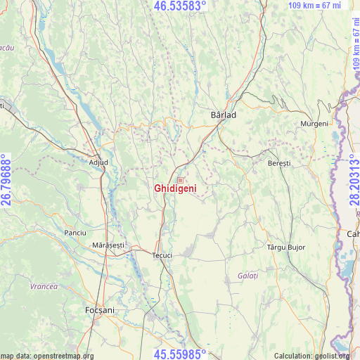
Ghidigeni GPS coordinates[2]
46° 3' 0" North, 27° 30' 0" East
| Map corner | latitude | longitude |
|---|---|---|
| Upper-left | 46.53583°, | 26.79688° |
| Center: | 46.05°, | 27.5° |
| Lower-right: | 45.55985°, | 28.20313° |
| Map W x H: | 108.5×108.5 km | = 67.4×67.4mi |
| max Lat: | 48.23793° ⇑44% North |
| Ghidigeni: | 46.05° |
| min Lat: | ⇓56% South 43.65638° |
| min Long | Ghidigeni | max Long |
| 20.31667° | 27.5° | 29.65403° |
| W 90.8%⇐ | ⇒9.2% E |
Elevation
Elevation of Ghidigeni is 102 m = 335 ft, and this is 152.9 m = 502 ft below average elevation for this country.
| Max E: |
1278 m = 4193 ft | 77.7% |
| Avg. | 254.9 m = 836 ft | |
| Ghidigeni | 102 m = 335 ft | |
Min E: |
-2 m = -7 ft | 22.3% |
See also: Romania elevation on elevation.city.
Geographical zone
Ghidigeni is located in North temperate zone (between Tropic of Cancer and the Arctic Circle). Distance of this North polar circle is 2280.9 km =1417.3 mi to North.| Distance of | km | miles | from Ghidigeni |
|---|---|---|---|
| North Pole | 4886.8 | 3036.5 | to North |
| Arctic Circle | 2280.9 | 1417.3 | to North |
| Tropic Cancer | 2514.4 | 1562.4 | to South |
| Equator | 5120.3 | 3181.6 | to South |


Nearby cities:
15 places around Ghidigeni: (largest is in red/bold)
• Brăhășești
10.5 km =6.5 mi,  259°
259°
• Cerţeşti
9.7 km =6 mi,  112°
112°
• Ciorăști
8 km =5 mi,  332°
332°
• Cârlomănești
9.8 km =6.1 mi,  139°
139°
• Gara Berheci
9.7 km =6 mi,  209°
209°
• Gefu
3 km =1.9 mi,  24°
24°
• Gohor
7.9 km =4.9 mi,  283°
283°
• Negrilești
10.4 km =6.5 mi,  188°
188°
• Nărtești
8.2 km =5.1 mi,  239°
239°
• Pochidia
6.8 km =4.2 mi,  96°
96°
• Priponeşti
6.3 km =3.9 mi,  305°
305°
• Slobozia Corni
6.7 km =4.2 mi, 193°
• Sălceni
5.6 km =3.5 mi,  72°
72°
• Tutova
8.4 km =5.2 mi,  27°
27°
• Tălpigi
5.1 km =3.2 mi,  204°
204°
Sources, notices
• [Note1] Compared only with cities in Romania existing in our database
• [Src1] Map data: © OpenStreetMap contributors (CC-BY-SA)
• [Src2] Other city data from geonames.org with taken over terms of usage.
• [Src3] Geographical zone / Annual Mean Temperature by Robert A. Rohde @ Wikipedia
