Mogoşoaia geodata
Mogoşoaia (Ilfov) is a seat of a second-order administrative division; located in Romania in Europe/Bucharest (GMT+3) time zone. With population of 5,304 people, there are 693 cities with bigger population in this country. Compared to other cities in Romania, 84.6% of cities are located further ↑North; 62.9% of cities are located further ←West and 79.9% of cities have higher elevation than Mogoşoaia. Note1


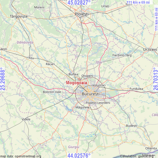
Mogoşoaia GPS coordinates[2]
44° 31' 45.012" North, 26° 0' 0" East
| Map corner | latitude | longitude |
|---|---|---|
| Upper-left | 45.02827°, | 25.29688° |
| Center: | 44.52917°, | 26° |
| Lower-right: | 44.02576°, | 26.70313° |
| Map W x H: | 111.5×111.5 km | = 69.3×69.3mi |
| max Lat: | 48.23793° ⇑84.6% North |
| Mogoşoaia: | 44.52917° |
| min Lat: | ⇓15.4% South 43.65638° |
| min Long | Mogoşoaia | max Long |
| 20.31667° | 26° | 29.65403° |
| W 62.9%⇐ | ⇒37.1% E |
Elevation
Elevation of Mogoşoaia is 95 m = 312 ft, and this is 159.9 m = 525 ft below average elevation for this country.
| Max E: |
1278 m = 4193 ft | 79.9% |
| Avg. | 254.9 m = 836 ft | |
| Mogoşoaia | 95 m = 312 ft | |
Min E: |
-2 m = -7 ft | 20.1% |
See also: Romania elevation on elevation.city.
Geographical zone
Mogoşoaia is located in North temperate zone (between Tropic of Cancer and the Arctic Circle). Distance of this Northern Tropic circle is 2345.3 km =1457.3 mi to South.| Distance of | km | miles | from Mogoşoaia |
|---|---|---|---|
| North Pole | 5055.9 | 3141.6 | to North |
| Arctic Circle | 2450 | 1522.4 | to North |
| Tropic Cancer | 2345.3 | 1457.3 | to South |
| Equator | 4951.2 | 3076.5 | to South |


Nearby cities:
15 places around Mogoşoaia: (largest is in red/bold)
• Buciumeni
3.6 km =2.2 mi,  308°
308°
• Buftea
5.4 km =3.4 mi, 311°
• Chiajna
8 km =5 mi,  195°
195°
• Chitila
2.7 km =1.7 mi,  210°
210°
• Corbeanca
8.8 km =5.5 mi,  26°
26°
• Dragomireşti-Vale
7.9 km =4.9 mi,  220°
220°
• Dragomirești-Deal
8.6 km =5.3 mi, 210°
• Dudu
8.1 km =5 mi,  185°
185°
• Mânăstirea
8 km =5 mi,  317°
317°
• Otopeni
5.8 km =3.6 mi,  66°
66°
• Rudeni
6.7 km =4.2 mi, 198°
• Samurcași
8.1 km =5 mi, 309°
• Sector 1
5.6 km =3.5 mi,  136°
136°
• Tamași
6.2 km =3.9 mi,  5°
5°
• Zurbaua
8.1 km =5 mi,  237°
237°
Sources, notices
• [Note1] Compared only with cities in Romania existing in our database
• [Src1] Map data: © OpenStreetMap contributors (CC-BY-SA)
• [Src2] Other city data from geonames.org with taken over terms of usage.
• [Src3] Geographical zone / Annual Mean Temperature by Robert A. Rohde @ Wikipedia
