Sector 1 geodata
Sector 1 (Bucureşti) is a section of populated place; located in Romania in Europe/Bucharest (GMT+3) time zone. With population of 225,453 people, there are 14 cities with bigger population in this country. Compared to other cities in Romania, 85.4% of cities are located further ↑North; 63.9% of cities are located further ←West and 82.5% of cities have higher elevation than Sector 1. Note1


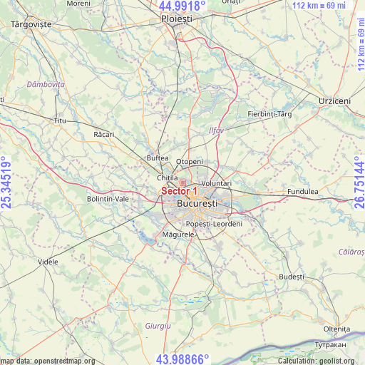
Sector 1 GPS coordinates[2]
44° 29' 32.604" North, 26° 2' 53.916" East
| Map corner | latitude | longitude |
|---|---|---|
| Upper-left | 44.9918°, | 25.34519° |
| Center: | 44.49239°, | 26.04831° |
| Lower-right: | 43.98866°, | 26.75144° |
| Map W x H: | 111.5×111.5 km | = 69.3×69.3mi |
| max Lat: | 48.23793° ⇑85.4% North |
| Sector 1: | 44.49239° |
| min Lat: | ⇓14.6% South 43.65638° |
| min Long | Sector 1 | max Long |
| 20.31667° | 26.04831° | 29.65403° |
| W 63.9%⇐ | ⇒36.1% E |
Elevation
Elevation of Sector 1 is 86 m = 282 ft, and this is 168.9 m = 554 ft below average elevation for this country.
| Max E: |
1278 m = 4193 ft | 82.5% |
| Avg. | 254.9 m = 836 ft | |
| Sector 1 | 86 m = 282 ft | |
Min E: |
-2 m = -7 ft | 17.5% |
See also: Sector 1 elevation on elevation.city.
Geographical zone
Sector 1 is located in North temperate zone (between Tropic of Cancer and the Arctic Circle). Distance of this Northern Tropic circle is 2341.2 km =1454.8 mi to South.| Distance of | km | miles | from Sector 1 |
|---|---|---|---|
| North Pole | 5060 | 3144.1 | to North |
| Arctic Circle | 2454.1 | 1524.9 | to North |
| Tropic Cancer | 2341.2 | 1454.8 | to South |
| Equator | 4947.1 | 3074 | to South |


Nearby cities:
15 places around Sector 1: (largest is in red/bold)
• Bucharest
8.1 km =5 mi,  145°
145°
• Buciumeni
9.2 km =5.7 mi,  313°
313°
• Bucuresti
8.1 km =5 mi, 151°
• Chiajna
7 km =4.3 mi,  238°
238°
• Chitila
5.5 km =3.4 mi,  288°
288°
• Dragomireşti-Vale
9.2 km =5.7 mi,  257°
257°
• Dragomirești-Deal
8.9 km =5.5 mi,  247°
247°
• Dudu
6.1 km =3.8 mi,  228°
228°
• Mogoşoaia
5.6 km =3.5 mi,  316°
316°
• Otopeni
6.6 km =4.1 mi,  12°
12°
• Roșu
5.5 km =3.4 mi,  212°
212°
• Rudeni
6.4 km =4 mi, 249°
• Sector 2
8 km =5 mi,  123°
123°
• Sector 6
6.8 km =4.2 mi,  201°
201°
• Voluntari
9.9 km =6.2 mi,  91°
91°
Sources, notices
• [Note1] Compared only with cities in Romania existing in our database
• [Src1] Map data: © OpenStreetMap contributors (CC-BY-SA)
• [Src2] Other city data from geonames.org with taken over terms of usage.
• [Src3] Geographical zone / Annual Mean Temperature by Robert A. Rohde @ Wikipedia
