Milcovul geodata
Milcovul (Vrancea) is a seat of a second-order administrative division; located in Romania in Europe/Bucharest (GMT+3) time zone. With population of 8,547 people, there are 275 cities with bigger population in this country. Compared to other cities in Romania, 52.8% of cities are located further ↑North; 87.5% of cities are located further ←West and 95% of cities have higher elevation than Milcovul. Note1


Milcovul GPS coordinates[2]
45° 39' 0" North, 27° 15' 0" East
| Map corner | latitude | longitude |
|---|---|---|
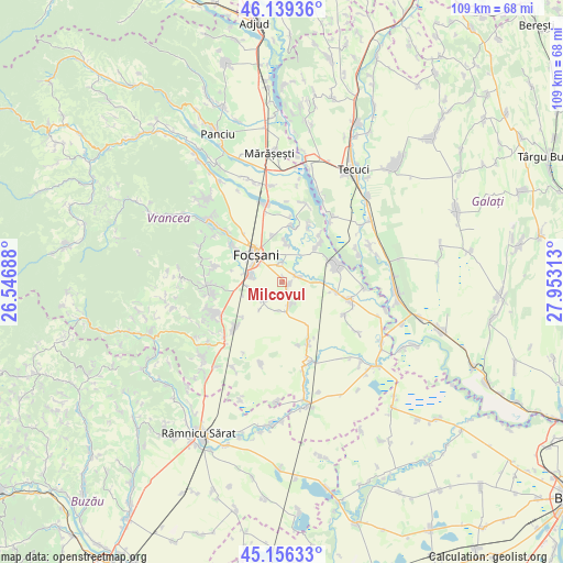
| Upper-left | 46.13936°, | 26.54688° |
| Center: | 45.65°, | 27.25° |
| Lower-right: | 45.15633°, | 27.95313° |
| Map W x H: | 109.3×109.3 km | = 67.9×67.9mi |
| max Lat: | 48.23793° ⇑52.8% North |
| Milcovul: | 45.65° |
| min Lat: | ⇓47.2% South 43.65638° |
| min Long | Milcovul | max Long |
| 20.31667° | 27.25° | 29.65403° |
| W 87.5%⇐ | ⇒12.5% E |
Elevation
Elevation of Milcovul is 35 m = 115 ft, and this is 219.9 m = 721 ft below average elevation for this country.
| Max E: |
1278 m = 4193 ft | 95% |
| Avg. | 254.9 m = 836 ft | |
| Milcovul | 35 m = 115 ft | |
Min E: |
-2 m = -7 ft | 5% |
See also: Romania elevation on elevation.city.
Geographical zone
Milcovul is located in North temperate zone (between Tropic of Cancer and the Arctic Circle). Distance of this North polar circle is 2325.4 km =1444.9 mi to North.| Distance of | km | miles | from Milcovul |
|---|---|---|---|
| North Pole | 4931.3 | 3064.2 | to North |
| Arctic Circle | 2325.4 | 1444.9 | to North |
| Tropic Cancer | 2469.9 | 1534.7 | to South |
| Equator | 5075.8 | 3154 | to South |


Nearby cities:
15 places around Milcovul: (largest is in red/bold)
• Biliești
11 km =6.8 mi,  44°
44°
• Ceardac
6.9 km =4.3 mi,  288°
288°
• Focșani
7.6 km =4.7 mi,  317°
317°
• Goleşti
9.3 km =5.8 mi,  281°
281°
• Gologanu
4.8 km =3 mi,  160°
160°
• Jiliște
5.5 km =3.4 mi,  186°
186°
• Jorăști
7.3 km =4.5 mi,  8°
8°
• Lămotești
1 km =0.6 mi, 5°
• Mirceștii Noi
11.3 km =7 mi, 8°
• Oreavu
10.2 km =6.3 mi,  228°
228°
• Petrești
9.2 km =5.7 mi,  348°
348°
• Răstoaca
3.1 km =1.9 mi,  67°
67°
• Slobozia-Ciorăşti
5.4 km =3.4 mi, 226°
• Slobozia-Câmpineanca
10.6 km =6.6 mi,  301°
301°
• Vânători
9.3 km =5.8 mi,  0°
0°
Sources, notices
• [Note1] Compared only with cities in Romania existing in our database
• [Src1] Map data: © OpenStreetMap contributors (CC-BY-SA)
• [Src2] Other city data from geonames.org with taken over terms of usage.
• [Src3] Geographical zone / Annual Mean Temperature by Robert A. Rohde @ Wikipedia
