Gologanu geodata
Gologanu (Vrancea) is a seat of a second-order administrative division; located in Romania in Europe/Bucharest (GMT+3) time zone. With population of 3,439 people, there are 1461 cities with bigger population in this country. Compared to other cities in Romania, 53.4% of cities are located further ↑North; 87.9% of cities are located further ←West and 95.3% of cities have higher elevation than Gologanu. Note1


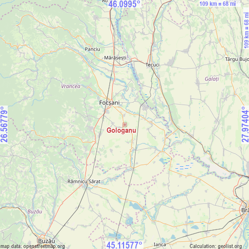
Gologanu GPS coordinates[2]
45° 36' 35.244" North, 27° 16' 15.276" East
| Map corner | latitude | longitude |
|---|---|---|
| Upper-left | 46.0995°, | 26.56779° |
| Center: | 45.60979°, | 27.27091° |
| Lower-right: | 45.11577°, | 27.97404° |
| Map W x H: | 109.4×109.4 km | = 68×68mi |
| max Lat: | 48.23793° ⇑53.4% North |
| Gologanu: | 45.60979° |
| min Lat: | ⇓46.6% South 43.65638° |
| min Long | Gologanu | max Long |
| 20.31667° | 27.27091° | 29.65403° |
| W 87.9%⇐ | ⇒12.1% E |
Elevation
Elevation of Gologanu is 34 m = 112 ft, and this is 220.9 m = 725 ft below average elevation for this country.
| Max E: |
1278 m = 4193 ft | 95.3% |
| Avg. | 254.9 m = 836 ft | |
| Gologanu | 34 m = 112 ft | |
Min E: |
-2 m = -7 ft | 4.7% |
See also: Romania elevation on elevation.city.
Geographical zone
Gologanu is located in North temperate zone (between Tropic of Cancer and the Arctic Circle). Distance of this North polar circle is 2329.8 km =1447.7 mi to North.| Distance of | km | miles | from Gologanu |
|---|---|---|---|
| North Pole | 4935.7 | 3066.9 | to North |
| Arctic Circle | 2329.8 | 1447.7 | to North |
| Tropic Cancer | 2465.4 | 1531.9 | to South |
| Equator | 5071.3 | 3151.2 | to South |


Nearby cities:
15 places around Gologanu: (largest is in red/bold)
• Bordeasca Veche
8.1 km =5 mi,  153°
153°
• Ceardac
10.5 km =6.5 mi,  309°
309°
• Focșani
12.1 km =7.5 mi,  325°
325°
• Goleşti
12.4 km =7.7 mi,  300°
300°
• Gugeşti
11.7 km =7.3 mi,  245°
245°
• Jiliște
2.5 km =1.6 mi, 246°
• Jorăști
11.7 km =7.3 mi,  357°
357°
• Lămotești
5.6 km =3.5 mi,  344°
344°
• Milcovul
4.8 km =3 mi, 340°
• Mărtinești
12.1 km =7.5 mi,  167°
167°
• Oreavu
9.6 km =6 mi,  256°
256°
• Răstoaca
5.8 km =3.6 mi,  12°
12°
• Slobozia-Ciorăşti
5.6 km =3.5 mi,  277°
277°
• Tătăranu
10.9 km =6.8 mi,  161°
161°
• Vulturu
11.4 km =7.1 mi,  86°
86°
Sources, notices
• [Note1] Compared only with cities in Romania existing in our database
• [Src1] Map data: © OpenStreetMap contributors (CC-BY-SA)
• [Src2] Other city data from geonames.org with taken over terms of usage.
• [Src3] Geographical zone / Annual Mean Temperature by Robert A. Rohde @ Wikipedia
