Slobozia-Ciorăşti geodata
Slobozia-Ciorăşti (Vrancea) is a seat of a second-order administrative division; located in Romania in Europe/Bucharest (GMT+3) time zone. With population of 2,077 people, there are 2535 cities with bigger population in this country. Compared to other cities in Romania, 53.4% of cities are located further ↑North; 86.8% of cities are located further ←West and 92.2% of cities have higher elevation than Slobozia-Ciorăşti. Note1


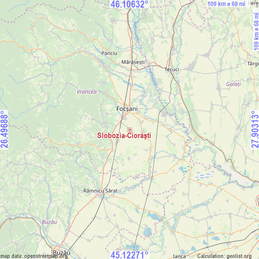
Slobozia-Ciorăşti GPS coordinates[2]
45° 37' 0.012" North, 27° 12' 0" East
| Map corner | latitude | longitude |
|---|---|---|
| Upper-left | 46.10632°, | 26.49688° |
| Center: | 45.61667°, | 27.2° |
| Lower-right: | 45.12271°, | 27.90313° |
| Map W x H: | 109.4×109.4 km | = 68×68mi |
| max Lat: | 48.23793° ⇑53.4% North |
| Slobozia-Ciorăşti: | 45.61667° |
| min Lat: | ⇓46.6% South 43.65638° |
| min Long | Slobozia-Cioră | max Long |
| 20.31667° | 27.2° | 29.65403° |
| W 86.8%⇐ | ⇒13.2% E |
Elevation
Elevation of Slobozia-Ciorăşti is 48 m = 157 ft, and this is 206.9 m = 679 ft below average elevation for this country.
| Max E: |
1278 m = 4193 ft | 92.2% |
| Avg. | 254.9 m = 836 ft | |
| Slobozia-Ciorăşti | 48 m = 157 ft | |
Min E: |
-2 m = -7 ft | 7.8% |
See also: Romania elevation on elevation.city.
Geographical zone
Slobozia-Ciorăşti is located in North temperate zone (between Tropic of Cancer and the Arctic Circle). Distance of this North polar circle is 2329.1 km =1447.2 mi to North.| Distance of | km | miles | from Slobozia-Ciorăşti |
|---|---|---|---|
| North Pole | 4935 | 3066.5 | to North |
| Arctic Circle | 2329.1 | 1447.2 | to North |
| Tropic Cancer | 2466.2 | 1532.4 | to South |
| Equator | 5072.1 | 3151.7 | to South |


Nearby cities:
15 places around Slobozia-Ciorăşti: (largest is in red/bold)
• Ceardac
6.5 km =4 mi,  335°
335°
• Cârligele
10.7 km =6.6 mi,  313°
313°
• Focșani
9.4 km =5.8 mi,  352°
352°
• Goleşti
7.6 km =4.7 mi,  317°
317°
• Gologanu
5.6 km =3.5 mi,  97°
97°
• Gugeşti
7.6 km =4.7 mi,  223°
223°
• Jiliște
3.7 km =2.3 mi,  118°
118°
• Lămotești
6.1 km =3.8 mi,  40°
40°
• Milcovul
5.4 km =3.4 mi,  46°
46°
• Oreavu
4.9 km =3 mi,  231°
231°
• Popești
9.7 km =6 mi,  255°
255°
• Răstoaca
8.4 km =5.2 mi, 54°
• Slobozia-Câmpineanca
10.6 km =6.6 mi,  330°
330°
• Urecheşti
10.5 km =6.5 mi, 259°
• Valea Cotești
9.9 km =6.2 mi,  281°
281°
Sources, notices
• [Note1] Compared only with cities in Romania existing in our database
• [Src1] Map data: © OpenStreetMap contributors (CC-BY-SA)
• [Src2] Other city data from geonames.org with taken over terms of usage.
• [Src3] Geographical zone / Annual Mean Temperature by Robert A. Rohde @ Wikipedia
