Mija geodata
Mija (Dâmboviţa) is a populated place; located in Romania in Europe/Bucharest (GMT+3) time zone. With population of 2,719 people, there are 1972 cities with bigger population in this country. Compared to other cities in Romania, 72.6% of cities are located further ↑North; 57.1% of cities are located further ←West and 58.6% of cities have lower elevation than Mija. Note1


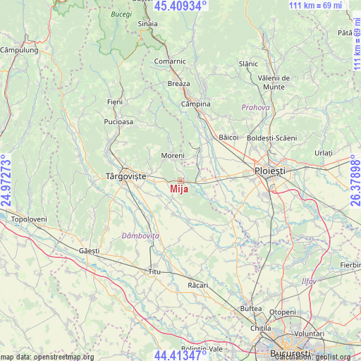
Mija GPS coordinates[2]
44° 54' 48.816" North, 25° 40' 33.06" East
| Map corner | latitude | longitude |
|---|---|---|
| Upper-left | 45.40934°, | 24.97273° |
| Center: | 44.91356°, | 25.67585° |
| Lower-right: | 44.41347°, | 26.37898° |
| Map W x H: | 110.7×110.7 km | = 68.8×68.8mi |
| max Lat: | 48.23793° ⇑72.6% North |
| Mija: | 44.91356° |
| min Lat: | ⇓27.4% South 43.65638° |
| min Long | Mija | max Long |
| 20.31667° | 25.67585° | 29.65403° |
| W 57.1%⇐ | ⇒42.9% E |
Elevation
Elevation of Mija is 255 m = 837 ft, and this is 0.099999999999994 m = 0 ft above average elevation for this country.
| Max E: |
1278 m = 4193 ft | 41.4% |
| Mija | 255 m 837 ft | |
| Avg. | 254.9 m = 836 ft | |
Min E: |
-2 m = -7 ft | 58.6% |
See also: Romania elevation on elevation.city.
Geographical zone
Mija is located in North temperate zone (between Tropic of Cancer and the Arctic Circle). Distance of this Northern Tropic circle is 2388 km =1483.8 mi to South.| Distance of | km | miles | from Mija |
|---|---|---|---|
| North Pole | 5013.1 | 3115 | to North |
| Arctic Circle | 2407.3 | 1495.8 | to North |
| Tropic Cancer | 2388 | 1483.8 | to South |
| Equator | 4993.9 | 3103.1 | to South |


Nearby cities:
15 places around Mija: (largest is in red/bold)
• Adânca
5.3 km =3.3 mi,  280°
280°
• Bucşani
5.6 km =3.5 mi,  201°
201°
• Comişani
8 km =5 mi,  245°
245°
• Dițești
8.4 km =5.2 mi,  28°
28°
• Dărmăneşti
8.5 km =5.3 mi,  87°
87°
• Ghirdoveni
3 km =1.9 mi,  356°
356°
• Gura Ocniței
9 km =5.6 mi,  290°
290°
• Hăbeni
7.4 km =4.6 mi,  210°
210°
• I. L. Caragiale
2.1 km =1.3 mi,  101°
101°
• Moreni
8.1 km =5 mi,  342°
342°
• Mărginenii de Jos
8.3 km =5.2 mi,  52°
52°
• Mărginenii de Sus
6.3 km =3.9 mi,  71°
71°
• Rățoaia
7.3 km =4.5 mi,  174°
174°
• Săcueni
8.2 km =5.1 mi,  267°
267°
• Vlădeni
8.8 km =5.5 mi,  118°
118°
Sources, notices
• [Note1] Compared only with cities in Romania existing in our database
• [Src1] Map data: © OpenStreetMap contributors (CC-BY-SA)
• [Src2] Other city data from geonames.org with taken over terms of usage.
• [Src3] Geographical zone / Annual Mean Temperature by Robert A. Rohde @ Wikipedia
