Vlădeni geodata
Vlădeni (Dâmboviţa) is a seat of a second-order administrative division; located in Romania in Europe/Bucharest (GMT+2) time zone. With population of 2,963 people, there are 1804 cities with bigger population in this country. Compared to other cities in Romania, 73.9% of cities are located further ↑North; 58.6% of cities are located further ←West and 53.3% of cities have higher elevation than Vlădeni. Note1


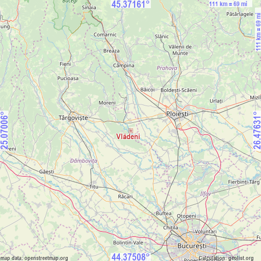
Vlădeni GPS coordinates[2]
44° 52' 31.8" North, 25° 46' 23.448" East
| Map corner | latitude | longitude |
|---|---|---|
| Upper-left | 45.37161°, | 25.07006° |
| Center: | 44.8755°, | 25.77318° |
| Lower-right: | 44.37508°, | 26.47631° |
| Map W x H: | 110.8×110.8 km | = 68.8×68.8mi |
| max Lat: | 48.23793° ⇑73.9% North |
| Vlădeni: | 44.8755° |
| min Lat: | ⇓26.1% South 43.65638° |
| min Long | Vlădeni | max Long |
| 20.31667° | 25.77318° | 29.65403° |
| W 58.6%⇐ | ⇒41.4% E |
Elevation
Elevation of Vlădeni is 195 m = 640 ft, and this is 59.9 m = 197 ft below average elevation for this country.
| Max E: |
1278 m = 4193 ft | 53.3% |
| Avg. | 254.9 m = 836 ft | |
| Vlădeni | 195 m = 640 ft | |
Min E: |
-2 m = -7 ft | 46.7% |
See also: Romania elevation on elevation.city.
Geographical zone
Vlădeni is located in North temperate zone (between Tropic of Cancer and the Arctic Circle). Distance of this Northern Tropic circle is 2383.8 km =1481.2 mi to South.| Distance of | km | miles | from Vlădeni |
|---|---|---|---|
| North Pole | 5017.4 | 3117.7 | to North |
| Arctic Circle | 2411.5 | 1498.4 | to North |
| Tropic Cancer | 2383.8 | 1481.2 | to South |
| Equator | 4989.7 | 3100.5 | to South |


Nearby cities:
15 places around Vlădeni: (largest is in red/bold)
• Brătășanca
7.2 km =4.5 mi,  24°
24°
• Băltița
7.6 km =4.7 mi,  123°
123°
• Coada Izvorului
4.1 km =2.5 mi, 119°
• Cocorăștii Grind
8.7 km =5.4 mi,  111°
111°
• Dărmăneşti
4.6 km =2.9 mi,  9°
9°
• Finta Mare
8.7 km =5.4 mi,  165°
165°
• Gheboaia
8.4 km =5.2 mi,  193°
193°
• I. L. Caragiale
6.7 km =4.2 mi,  304°
304°
• Mija
8.8 km =5.5 mi, 298°
• Măneşti
6.1 km =3.8 mi,  99°
99°
• Mărginenii de Sus
6.5 km =4 mi,  345°
345°
• Rățoaia
7.7 km =4.8 mi,  246°
246°
• Stoenești
8.7 km =5.4 mi,  51°
51°
• Ungureni
7.5 km =4.7 mi, 23°
• Zalhanaua
5.5 km =3.4 mi,  56°
56°
Sources, notices
• [Note1] Compared only with cities in Romania existing in our database
• [Src1] Map data: © OpenStreetMap contributors (CC-BY-SA)
• [Src2] Other city data from geonames.org with taken over terms of usage.
• [Src3] Geographical zone / Annual Mean Temperature by Robert A. Rohde @ Wikipedia
