Rățoaia geodata
Rățoaia (Dâmboviţa) is a populated place; located in Romania in Europe/Bucharest (GMT+3) time zone. With population of 514 people, there are 6913 cities with bigger population in this country. Compared to other cities in Romania, 75% of cities are located further ↑North; 57.4% of cities are located further ←West and 53.7% of cities have higher elevation than Rățoaia. Note1


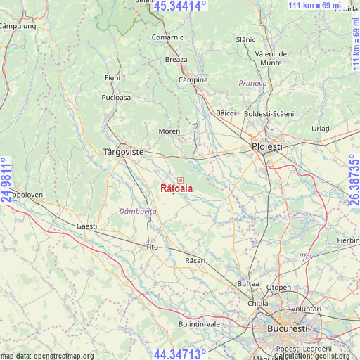
Rățoaia GPS coordinates[2]
44° 50' 52.044" North, 25° 41' 3.192" East
| Map corner | latitude | longitude |
|---|---|---|
| Upper-left | 45.34414°, | 24.9811° |
| Center: | 44.84779°, | 25.68422° |
| Lower-right: | 44.34713°, | 26.38735° |
| Map W x H: | 110.9×110.9 km | = 68.9×68.9mi |
| max Lat: | 48.23793° ⇑75% North |
| Rățoaia: | 44.84779° |
| min Lat: | ⇓25% South 43.65638° |
| min Long | Rățoaia | max Long |
| 20.31667° | 25.68422° | 29.65403° |
| W 57.4%⇐ | ⇒42.6% E |
Elevation
Elevation of Rățoaia is 193 m = 633 ft, and this is 61.9 m = 203 ft below average elevation for this country.
| Max E: |
1278 m = 4193 ft | 53.7% |
| Avg. | 254.9 m = 836 ft | |
| Rățoaia | 193 m = 633 ft | |
Min E: |
-2 m = -7 ft | 46.3% |
See also: Romania elevation on elevation.city.
Geographical zone
Rățoaia is located in North temperate zone (between Tropic of Cancer and the Arctic Circle). Distance of this Northern Tropic circle is 2380.7 km =1479.3 mi to South.| Distance of | km | miles | from Rățoaia |
|---|---|---|---|
| North Pole | 5020.5 | 3119.6 | to North |
| Arctic Circle | 2414.6 | 1500.4 | to North |
| Tropic Cancer | 2380.7 | 1479.3 | to South |
| Equator | 4986.6 | 3098.5 | to South |


Nearby cities:
15 places around Rățoaia: (largest is in red/bold)
• Adânca
10.2 km =6.3 mi,  324°
324°
• Bucşani
3.4 km =2.1 mi,  307°
307°
• Băleni Sârbi
5.3 km =3.3 mi,  229°
229°
• Coada Izvorului
10.6 km =6.6 mi,  84°
84°
• Comişani
8.9 km =5.5 mi,  296°
296°
• Dobra
7.6 km =4.7 mi,  160°
160°
• Gheboaia
7.2 km =4.5 mi,  134°
134°
• Ghirdoveni
10.4 km =6.5 mi,  355°
355°
• Hăbeni
4.5 km =2.8 mi,  282°
282°
• I. L. Caragiale
7 km =4.3 mi,  11°
11°
• Ilfoveni
9.9 km =6.2 mi,  256°
256°
• Mija
7.3 km =4.5 mi,  354°
354°
• Mărcești
5.1 km =3.2 mi, 157°
• Racovița
5.1 km =3.2 mi, 259°
• Vlădeni
7.7 km =4.8 mi,  66°
66°
Sources, notices
• [Note1] Compared only with cities in Romania existing in our database
• [Src1] Map data: © OpenStreetMap contributors (CC-BY-SA)
• [Src2] Other city data from geonames.org with taken over terms of usage.
• [Src3] Geographical zone / Annual Mean Temperature by Robert A. Rohde @ Wikipedia
