Mica geodata
Mica (Cluj) is a seat of a second-order administrative division; located in Romania in Europe/Bucharest (GMT+3) time zone. With population of 3,799 people, there are 1264 cities with bigger population in this country. Compared to other cities in Romania, 82.2% of cities are located further ↓South; 70.7% of cities are located further →East and 54.1% of cities have lower elevation than Mica. Note1


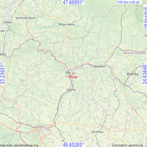
Mica GPS coordinates[2]
47° 7' 59.988" North, 23° 55' 59.988" East
| Map corner | latitude | longitude |
|---|---|---|
| Upper-left | 47.60951°, | 23.23021° |
| Center: | 47.13333°, | 23.93333° |
| Lower-right: | 46.65285°, | 24.63646° |
| Map W x H: | 106.4×106.4 km | = 66.1×66.1mi |
| max Lat: | 48.23793° ⇑17.8% North |
| Mica: | 47.13333° |
| min Lat: | ⇓82.2% South 43.65638° |
| min Long | Mica | max Long |
| 20.31667° | 23.93333° | 29.65403° |
| W 29.3%⇐ | ⇒70.7% E |
Elevation
Elevation of Mica is 234 m = 768 ft, and this is 20.9 m = 69 ft below average elevation for this country.
| Max E: |
1278 m = 4193 ft | 45.9% |
| Avg. | 254.9 m = 836 ft | |
| Mica | 234 m = 768 ft | |
Min E: |
-2 m = -7 ft | 54.1% |
See also: Romania elevation on elevation.city.
Geographical zone
Mica is located in North temperate zone (between Tropic of Cancer and the Arctic Circle). Distance of this North polar circle is 2160.4 km =1342.4 mi to North.| Distance of | km | miles | from Mica |
|---|---|---|---|
| North Pole | 4766.3 | 2961.6 | to North |
| Arctic Circle | 2160.4 | 1342.4 | to North |
| Tropic Cancer | 2634.8 | 1637.2 | to South |
| Equator | 5240.7 | 3256.4 | to South |


Nearby cities:
15 places around Mica: (largest is in red/bold)
• Bața
7.8 km =4.8 mi,  37°
37°
• Bunești
9.2 km =5.7 mi,  205°
205°
• Ciceu-Mihăiești
6.6 km =4.1 mi,  28°
28°
• Cuzdrioara
3.9 km =2.4 mi,  341°
341°
• Căşeiu
7.5 km =4.7 mi,  317°
317°
• Dej
5.4 km =3.4 mi,  290°
290°
• Mintiu Gherlii
9.4 km =5.8 mi,  172°
172°
• Mănăstirea
1.9 km =1.2 mi,  180°
180°
• Mănășturel
4.5 km =2.8 mi,  19°
19°
• Nima
8 km =5 mi,  217°
217°
• Nireș
4.1 km =2.5 mi,  119°
119°
• Ocna Dejului
5.9 km =3.7 mi,  250°
250°
• Sânmărghita
5.3 km =3.3 mi,  60°
60°
• Unguraş
9 km =5.6 mi,  101°
101°
• Urișor
5.8 km =3.6 mi,  313°
313°
Sources, notices
• [Note1] Compared only with cities in Romania existing in our database
• [Src1] Map data: © OpenStreetMap contributors (CC-BY-SA)
• [Src2] Other city data from geonames.org with taken over terms of usage.
• [Src3] Geographical zone / Annual Mean Temperature by Robert A. Rohde @ Wikipedia
