Unguraş geodata
Unguraş (Cluj) is a seat of a second-order administrative division; located in Romania in Europe/Bucharest (GMT+3) time zone. With population of 3,031 people, there are 1737 cities with bigger population in this country. Compared to other cities in Romania, 81.7% of cities are located further ↓South; 68.6% of cities are located further →East and 68.6% of cities have lower elevation than Unguraş. Note1


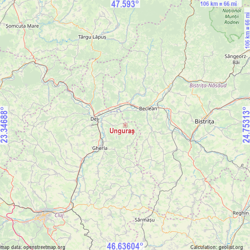
Unguraş GPS coordinates[2]
47° 7' 0.012" North, 24° 3' 0" East
| Map corner | latitude | longitude |
|---|---|---|
| Upper-left | 47.593°, | 23.34688° |
| Center: | 47.11667°, | 24.05° |
| Lower-right: | 46.63604°, | 24.75313° |
| Map W x H: | 106.4×106.4 km | = 66.1×66.1mi |
| max Lat: | 48.23793° ⇑18.3% North |
| Unguraş: | 47.11667° |
| min Lat: | ⇓81.7% South 43.65638° |
| min Long | Unguraş | max Long |
| 20.31667° | 24.05° | 29.65403° |
| W 31.4%⇐ | ⇒68.6% E |
Elevation
Elevation of Unguraş is 310 m = 1017 ft, and this is 55.1 m = 181 ft above average elevation for this country.
| Max E: |
1278 m = 4193 ft | 31.4% |
| Unguraş | 310 m 1017 ft | |
| Avg. | 254.9 m = 836 ft | |
Min E: |
-2 m = -7 ft | 68.6% |
See also: Romania elevation on elevation.city.
Geographical zone
Unguraş is located in North temperate zone (between Tropic of Cancer and the Arctic Circle). Distance of this North polar circle is 2162.3 km =1343.6 mi to North.| Distance of | km | miles | from Unguraş |
|---|---|---|---|
| North Pole | 4768.2 | 2962.8 | to North |
| Arctic Circle | 2162.3 | 1343.6 | to North |
| Tropic Cancer | 2633 | 1636.1 | to South |
| Equator | 5238.9 | 3255.3 | to South |


Nearby cities:
15 places around Unguraş: (largest is in red/bold)
• Batin
5 km =3.1 mi,  169°
169°
• Bața
9 km =5.6 mi,  332°
332°
• Braniştea
5.7 km =3.5 mi,  12°
12°
• Cireșoaia
3 km =1.9 mi,  17°
17°
• Coldău
9.5 km =5.9 mi,  41°
41°
• Cristeștii Ciceului
9.2 km =5.7 mi, 22°
• Malin
6.6 km =4.1 mi,  87°
87°
• Mica
9 km =5.6 mi,  281°
281°
• Măluț
7.5 km =4.7 mi,  33°
33°
• Mănăstirea
8.8 km =5.5 mi,  270°
270°
• Mănășturel
9.5 km =5.9 mi,  309°
309°
• Nireș
5.2 km =3.2 mi, 267°
• Reteag
9.1 km =5.7 mi,  344°
344°
• Sânmărghita
6.1 km =3.8 mi,  316°
316°
• Uriu
9.3 km =5.8 mi,  0°
0°
Sources, notices
• [Note1] Compared only with cities in Romania existing in our database
• [Src1] Map data: © OpenStreetMap contributors (CC-BY-SA)
• [Src2] Other city data from geonames.org with taken over terms of usage.
• [Src3] Geographical zone / Annual Mean Temperature by Robert A. Rohde @ Wikipedia
