Lihulești geodata
Lihulești (Gorj) is a populated place; located in Romania in Europe/Bucharest (GMT+3) time zone. With population of 860 people, there are 4784 cities with bigger population in this country. Compared to other cities in Romania, 70.1% of cities are located further ↑North; 74.7% of cities are located further →East and 72.5% of cities have lower elevation than Lihulești. Note1


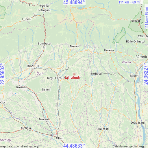
Lihulești GPS coordinates[2]
44° 59' 8.844" North, 23° 39' 32.904" East
| Map corner | latitude | longitude |
|---|---|---|
| Upper-left | 45.48094°, | 22.95602° |
| Center: | 44.98579°, | 23.65914° |
| Lower-right: | 44.48633°, | 24.36227° |
| Map W x H: | 110.6×110.6 km | = 68.7×68.7mi |
| max Lat: | 48.23793° ⇑70.1% North |
| Lihulești: | 44.98579° |
| min Lat: | ⇓29.9% South 43.65638° |
| min Long | Lihulești | max Long |
| 20.31667° | 23.65914° | 29.65403° |
| W 25.3%⇐ | ⇒74.7% E |
Elevation
Elevation of Lihulești is 337 m = 1106 ft, and this is 82.1 m = 269 ft above average elevation for this country.
| Max E: |
1278 m = 4193 ft | 27.5% |
| Lihulești | 337 m 1106 ft | |
| Avg. | 254.9 m = 836 ft | |
Min E: |
-2 m = -7 ft | 72.5% |
See also: Romania elevation on elevation.city.
Geographical zone
Lihulești is located in North temperate zone (between Tropic of Cancer and the Arctic Circle). Distance of this Northern Tropic circle is 2396 km =1488.8 mi to South.| Distance of | km | miles | from Lihulești |
|---|---|---|---|
| North Pole | 5005.1 | 3110 | to North |
| Arctic Circle | 2399.2 | 1490.8 | to North |
| Tropic Cancer | 2396 | 1488.8 | to South |
| Equator | 5002 | 3108.1 | to South |


Nearby cities:
15 places around Lihulești: (largest is in red/bold)
• Albeni
7 km =4.3 mi,  318°
318°
• Berleşti
7.7 km =4.8 mi,  175°
175°
• Bolbocești
5.5 km =3.4 mi,  294°
294°
• Bucșana
9.7 km =6 mi,  26°
26°
• Bustuchin
6.2 km =3.9 mi,  110°
110°
• Călugăreasa
6.4 km =4 mi,  347°
347°
• Cărbunești-Sat
9.7 km =6 mi,  246°
246°
• Licurici
8.4 km =5.2 mi,  203°
203°
• Logrești Moșteni
9.5 km =5.9 mi,  157°
157°
• Poiana Seciuri
5.3 km =3.3 mi,  82°
82°
• Prigoria
9.2 km =5.7 mi,  11°
11°
• Ruget
9.1 km =5.7 mi,  68°
68°
• Seciurile
7 km =4.3 mi,  55°
55°
• Valea Pojarului
8 km =5 mi,  138°
138°
• Ștefănești
7.3 km =4.5 mi,  265°
265°
Sources, notices
• [Note1] Compared only with cities in Romania existing in our database
• [Src1] Map data: © OpenStreetMap contributors (CC-BY-SA)
• [Src2] Other city data from geonames.org with taken over terms of usage.
• [Src3] Geographical zone / Annual Mean Temperature by Robert A. Rohde @ Wikipedia
