Ștefănești geodata
Ștefănești (Gorj) is a populated place; located in Romania in Europe/Bucharest (GMT+3) time zone. With population of 588 people, there are 6301 cities with bigger population in this country. Compared to other cities in Romania, 70.4% of cities are located further ↑North; 76.1% of cities are located further →East and 54.6% of cities have lower elevation than Ștefănești. Note1


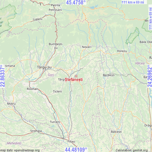
Ștefănești GPS coordinates[2]
44° 58' 50.16" North, 23° 33' 59.364" East
| Map corner | latitude | longitude |
|---|---|---|
| Upper-left | 45.4758°, | 22.86337° |
| Center: | 44.9806°, | 23.56649° |
| Lower-right: | 44.48109°, | 24.26962° |
| Map W x H: | 110.6×110.6 km | = 68.7×68.7mi |
| max Lat: | 48.23793° ⇑70.4% North |
| Ștefănești: | 44.9806° |
| min Lat: | ⇓29.6% South 43.65638° |
| min Long | Ștefănești | max Long |
| 20.31667° | 23.56649° | 29.65403° |
| W 23.9%⇐ | ⇒76.1% E |
Elevation
Elevation of Ștefănești is 236 m = 774 ft, and this is 18.9 m = 62 ft below average elevation for this country.
| Max E: |
1278 m = 4193 ft | 45.4% |
| Avg. | 254.9 m = 836 ft | |
| Ștefănești | 236 m = 774 ft | |
Min E: |
-2 m = -7 ft | 54.6% |
See also: Romania elevation on elevation.city.
Geographical zone
Ștefănești is located in North temperate zone (between Tropic of Cancer and the Arctic Circle). Distance of this Northern Tropic circle is 2395.5 km =1488.5 mi to South.| Distance of | km | miles | from Ștefănești |
|---|---|---|---|
| North Pole | 5005.7 | 3110.4 | to North |
| Arctic Circle | 2399.8 | 1491.2 | to North |
| Tropic Cancer | 2395.5 | 1488.5 | to South |
| Equator | 5001.4 | 3107.7 | to South |


Nearby cities:
15 places around Ștefănești: (largest is in red/bold)
• Albeni
6.4 km =4 mi,  24°
24°
• Bengești
9.9 km =6.2 mi, 15°
• Berleşti
10.6 km =6.6 mi,  132°
132°
• Bobu
7.5 km =4.7 mi,  323°
323°
• Bolbocești
3.7 km =2.3 mi,  38°
38°
• Copăcioasa
12 km =7.5 mi,  299°
299°
• Călugăreasa
9 km =5.6 mi, 41°
• Cărbunești-Sat
3.7 km =2.3 mi,  204°
204°
• Jupâneşti
9.3 km =5.8 mi, 196°
• Licurici
8.1 km =5 mi,  150°
150°
• Lihulești
7.3 km =4.5 mi,  85°
85°
• Pojogeni
6.6 km =4.1 mi,  280°
280°
• Scoarţa
10 km =6.2 mi,  293°
293°
• Târgu Cărbuneşti
5.2 km =3.2 mi,  229°
229°
• Vierșani
11.7 km =7.3 mi,  193°
193°
Sources, notices
• [Note1] Compared only with cities in Romania existing in our database
• [Src1] Map data: © OpenStreetMap contributors (CC-BY-SA)
• [Src2] Other city data from geonames.org with taken over terms of usage.
• [Src3] Geographical zone / Annual Mean Temperature by Robert A. Rohde @ Wikipedia
