Berleşti geodata
Berleşti (Gorj) is a seat of a second-order administrative division; located in Romania in Europe/Bucharest (GMT+3) time zone. With population of 276 people, there are 7060 cities with bigger population in this country. Compared to other cities in Romania, 72.6% of cities are located further ↑North; 74.7% of cities are located further →East and 64.2% of cities have lower elevation than Berleşti. Note1


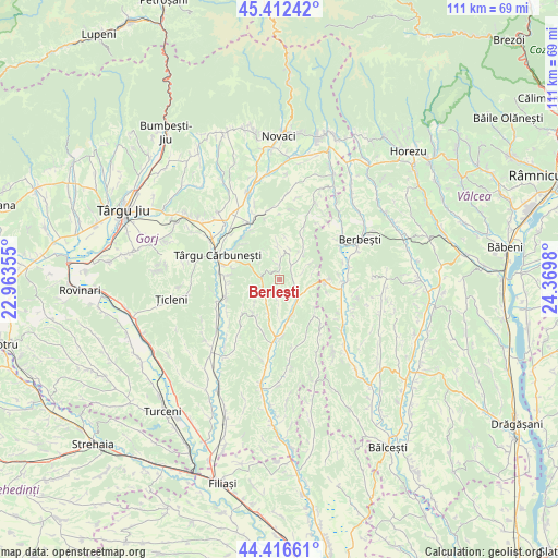
Berleşti GPS coordinates[2]
44° 55' 0.012" North, 23° 40' 0.012" East
| Map corner | latitude | longitude |
|---|---|---|
| Upper-left | 45.41242°, | 22.96355° |
| Center: | 44.91667°, | 23.66667° |
| Lower-right: | 44.41661°, | 24.3698° |
| Map W x H: | 110.7×110.7 km | = 68.8×68.8mi |
| max Lat: | 48.23793° ⇑72.6% North |
| Berleşti: | 44.91667° |
| min Lat: | ⇓27.4% South 43.65638° |
| min Long | Berleşti | max Long |
| 20.31667° | 23.66667° | 29.65403° |
| W 25.3%⇐ | ⇒74.7% E |
Elevation
Elevation of Berleşti is 285 m = 935 ft, and this is 30.1 m = 99 ft above average elevation for this country.
| Max E: |
1278 m = 4193 ft | 35.8% |
| Berleşti | 285 m 935 ft | |
| Avg. | 254.9 m = 836 ft | |
Min E: |
-2 m = -7 ft | 64.2% |
See also: Romania elevation on elevation.city.
Geographical zone
Berleşti is located in North temperate zone (between Tropic of Cancer and the Arctic Circle). Distance of this Northern Tropic circle is 2388.3 km =1484 mi to South.| Distance of | km | miles | from Berleşti |
|---|---|---|---|
| North Pole | 5012.8 | 3114.8 | to North |
| Arctic Circle | 2406.9 | 1495.6 | to North |
| Tropic Cancer | 2388.3 | 1484 | to South |
| Equator | 4994.3 | 3103.3 | to South |


Nearby cities:
15 places around Berleşti: (largest is in red/bold)
• Bustuchin
7.6 km =4.7 mi,  43°
43°
• Cărbunești-Sat
10.2 km =6.3 mi,  291°
291°
• Jupâneşti
10.7 km =6.6 mi,  259°
259°
• Licurici
3.9 km =2.4 mi,  270°
270°
• Lihulești
7.7 km =4.8 mi,  355°
355°
• Linia
10.7 km =6.6 mi,  97°
97°
• Logreşti
3.2 km =2 mi,  125°
125°
• Logrești Moșteni
3.2 km =2 mi,  110°
110°
• Negreni
8.3 km =5.2 mi,  193°
193°
• Piscoiu
9.9 km =6.2 mi,  136°
136°
• Poiana Seciuri
9.6 km =6 mi,  28°
28°
• Totea
8.4 km =5.2 mi,  212°
212°
• Valea Deșului
10.2 km =6.3 mi,  228°
228°
• Valea Pojarului
5.1 km =3.2 mi,  69°
69°
• Ștefănești
10.6 km =6.6 mi,  312°
312°
Sources, notices
• [Note1] Compared only with cities in Romania existing in our database
• [Src1] Map data: © OpenStreetMap contributors (CC-BY-SA)
• [Src2] Other city data from geonames.org with taken over terms of usage.
• [Src3] Geographical zone / Annual Mean Temperature by Robert A. Rohde @ Wikipedia
