Cordău geodata
Cordău (Bihor) is a populated place; located in Romania in Europe/Bucharest (GMT+3) time zone. With population of 1,440 people, there are 3269 cities with bigger population in this country. Compared to other cities in Romania, 77.8% of cities are located further ↓South; 94.6% of cities are located further →East and 59.5% of cities have lower elevation than Cordău. Note1


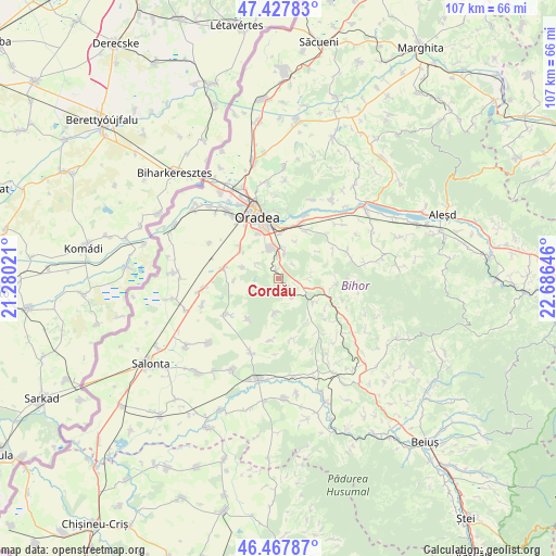
Cordău GPS coordinates[2]
46° 57' 0" North, 21° 58' 59.988" East
| Map corner | latitude | longitude |
|---|---|---|
| Upper-left | 47.42783°, | 21.28021° |
| Center: | 46.95°, | 21.98333° |
| Lower-right: | 46.46787°, | 22.68646° |
| Map W x H: | 106.7×106.7 km | = 66.3×66.3mi |
| max Lat: | 48.23793° ⇑22.2% North |
| Cordău: | 46.95° |
| min Lat: | ⇓77.8% South 43.65638° |
| min Long | Cordău | max Long |
| 20.31667° | 21.98333° | 29.65403° |
| W 5.4%⇐ | ⇒94.6% E |
Elevation
Elevation of Cordău is 261 m = 856 ft, and this is 6.1 m = 20 ft above average elevation for this country.
| Max E: |
1278 m = 4193 ft | 40.5% |
| Cordău | 261 m 856 ft | |
| Avg. | 254.9 m = 836 ft | |
Min E: |
-2 m = -7 ft | 59.5% |
See also: Romania elevation on elevation.city.
Geographical zone
Cordău is located in North temperate zone (between Tropic of Cancer and the Arctic Circle). Distance of this North polar circle is 2180.8 km =1355.1 mi to North.| Distance of | km | miles | from Cordău |
|---|---|---|---|
| North Pole | 4786.7 | 2974.3 | to North |
| Arctic Circle | 2180.8 | 1355.1 | to North |
| Tropic Cancer | 2614.4 | 1624.5 | to South |
| Equator | 5220.4 | 3243.8 | to South |


Nearby cities:
15 places around Cordău: (largest is in red/bold)
• Alparea
10.2 km =6.3 mi,  28°
28°
• Calea Mare
7.8 km =4.8 mi,  124°
124°
• Cheriu
7.5 km =4.7 mi,  22°
22°
• Cihei
5.9 km =3.7 mi,  336°
336°
• Haieu
5.1 km =3.2 mi,  12°
12°
• Hidişelu de Sus
5.1 km =3.2 mi,  90°
90°
• Leș
11 km =6.8 mi,  278°
278°
• Lăzăreni
11.2 km =7 mi,  145°
145°
• Mierlău
4.6 km =2.9 mi, 147°
• Nojorid
8.4 km =5.2 mi,  296°
296°
• Oșorhei
10.6 km =6.6 mi, 28°
• Sititelec
10.2 km =6.3 mi,  217°
217°
• Sînmartin
6.4 km =4 mi,  353°
353°
• Sărand
11.7 km =7.3 mi,  62°
62°
• Tășad
10.9 km =6.8 mi,  97°
97°
Sources, notices
• [Note1] Compared only with cities in Romania existing in our database
• [Src1] Map data: © OpenStreetMap contributors (CC-BY-SA)
• [Src2] Other city data from geonames.org with taken over terms of usage.
• [Src3] Geographical zone / Annual Mean Temperature by Robert A. Rohde @ Wikipedia
