Lăzarea geodata
Lăzarea (Harghita) is a seat of a second-order administrative division; located in Romania in Europe/Bucharest (GMT+3) time zone. With population of 3,555 people, there are 1397 cities with bigger population in this country. Compared to other cities in Romania, 72.8% of cities are located further ↓South; 54.9% of cities are located further ←West and 98.1% of cities have lower elevation than Lăzarea. Note1


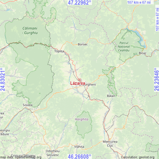
Lăzarea GPS coordinates[2]
46° 45' 0" North, 25° 31' 59.988" East
| Map corner | latitude | longitude |
|---|---|---|
| Upper-left | 47.22962°, | 24.83021° |
| Center: | 46.75°, | 25.53333° |
| Lower-right: | 46.26608°, | 26.23646° |
| Map W x H: | 107.1×107.1 km | = 66.5×66.5mi |
| max Lat: | 48.23793° ⇑27.2% North |
| Lăzarea: | 46.75° |
| min Lat: | ⇓72.8% South 43.65638° |
| min Long | Lăzarea | max Long |
| 20.31667° | 25.53333° | 29.65403° |
| W 54.9%⇐ | ⇒45.1% E |
Elevation
Elevation of Lăzarea is 775 m = 2543 ft, and this is 520.1 m = 1706 ft above average elevation for this country.
| Max E: |
1278 m = 4193 ft | 1.9% |
| Lăzarea | 775 m 2543 ft | |
| Avg. | 254.9 m = 836 ft | |
Min E: |
-2 m = -7 ft | 98.1% |
See also: Romania elevation on elevation.city.
Geographical zone
Lăzarea is located in North temperate zone (between Tropic of Cancer and the Arctic Circle). Distance of this North polar circle is 2203.1 km =1368.9 mi to North.| Distance of | km | miles | from Lăzarea |
|---|---|---|---|
| North Pole | 4808.9 | 2988.1 | to North |
| Arctic Circle | 2203.1 | 1368.9 | to North |
| Tropic Cancer | 2592.2 | 1610.7 | to South |
| Equator | 5198.1 | 3229.9 | to South |


Nearby cities:
15 places around Lăzarea: (largest is in red/bold)
• Borzont
8.7 km =5.4 mi,  225°
225°
• Chileni
8.2 km =5.1 mi,  158°
158°
• Ciumani
7.5 km =4.7 mi,  189°
189°
• Ditrău
7.5 km =4.7 mi,  350°
350°
• Fundoaia
16.6 km =10.3 mi,  340°
340°
• Gheorgheni
5.9 km =3.7 mi,  120°
120°
• Hodoșa
14.5 km =9 mi,  332°
332°
• Jolotca
12.7 km =7.9 mi,  358°
358°
• Joseni
6.1 km =3.8 mi,  204°
204°
• Remetea
7.3 km =4.5 mi,  300°
300°
• Subcetate
12.8 km =8 mi, 330°
• Suseni
9.4 km =5.8 mi,  172°
172°
• Sărmaş
15.7 km =9.8 mi, 341°
• Valea Strâmbă
8 km =5 mi,  140°
140°
• Voșlăbeni
13.5 km =8.4 mi,  145°
145°
Sources, notices
• [Note1] Compared only with cities in Romania existing in our database
• [Src1] Map data: © OpenStreetMap contributors (CC-BY-SA)
• [Src2] Other city data from geonames.org with taken over terms of usage.
• [Src3] Geographical zone / Annual Mean Temperature by Robert A. Rohde @ Wikipedia
