Gheorgheni geodata
Gheorgheni (Harghita) is a seat of a second-order administrative division; located in Romania in Europe/Bucharest (GMT+3) time zone. With population of 19,777 people, there are 107 cities with bigger population in this country. Compared to other cities in Romania, 72.2% of cities are located further ↓South; 56.1% of cities are located further ←West and 98.5% of cities have lower elevation than Gheorgheni. Note1


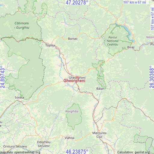
Gheorgheni GPS coordinates[2]
46° 43' 22.512" North, 25° 36' 1.98" East
| Map corner | latitude | longitude |
|---|---|---|
| Upper-left | 47.20278°, | 24.89743° |
| Center: | 46.72292°, | 25.60055° |
| Lower-right: | 46.23875°, | 26.30368° |
| Map W x H: | 107.2×107.2 km | = 66.6×66.6mi |
| max Lat: | 48.23793° ⇑27.8% North |
| Gheorgheni: | 46.72292° |
| min Lat: | ⇓72.2% South 43.65638° |
| min Long | Gheorgheni | max Long |
| 20.31667° | 25.60055° | 29.65403° |
| W 56.1%⇐ | ⇒43.9% E |
Elevation
Elevation of Gheorgheni is 816 m = 2677 ft, and this is 561.1 m = 1841 ft above average elevation for this country.
| Max E: |
1278 m = 4193 ft | 1.5% |
| Gheorgheni | 816 m 2677 ft | |
| Avg. | 254.9 m = 836 ft | |
Min E: |
-2 m = -7 ft | 98.5% |
See also: Romania elevation on elevation.city.
Geographical zone
Gheorgheni is located in North temperate zone (between Tropic of Cancer and the Arctic Circle). Distance of this North polar circle is 2206.1 km =1370.8 mi to North.| Distance of | km | miles | from Gheorgheni |
|---|---|---|---|
| North Pole | 4812 | 2990 | to North |
| Arctic Circle | 2206.1 | 1370.8 | to North |
| Tropic Cancer | 2589.2 | 1608.9 | to South |
| Equator | 5195.1 | 3228.1 | to South |


Nearby cities:
15 places around Gheorgheni: (largest is in red/bold)
• Borzont
11.7 km =7.3 mi,  254°
254°
• Bălan
17.8 km =11.1 mi,  116°
116°
• Chileni
5.1 km =3.2 mi,  204°
204°
• Ciumani
7.8 km =4.8 mi,  235°
235°
• Ditrău
12.2 km =7.6 mi,  328°
328°
• Hodoșa
19.7 km =12.2 mi,  323°
323°
• Izvoru Mureșului
12.4 km =7.7 mi,  149°
149°
• Jolotca
16.6 km =10.3 mi,  340°
340°
• Joseni
8.1 km =5 mi, 251°
• Lăzarea
5.9 km =3.7 mi,  300°
300°
• Remetea
13.3 km =8.3 mi, 300°
• Subcetate
18.2 km =11.3 mi, 320°
• Suseni
7.3 km =4.5 mi,  211°
211°
• Valea Strâmbă
3.2 km =2 mi,  181°
181°
• Voșlăbeni
8.5 km =5.3 mi,  162°
162°
Sources, notices
• [Note1] Compared only with cities in Romania existing in our database
• [Src1] Map data: © OpenStreetMap contributors (CC-BY-SA)
• [Src2] Other city data from geonames.org with taken over terms of usage.
• [Src3] Geographical zone / Annual Mean Temperature by Robert A. Rohde @ Wikipedia
