Mogoșești geodata
Mogoșești (Maramureş) is a populated place; located in Romania in Europe/Bucharest (GMT+3) time zone. With population of 739 people, there are 5345 cities with bigger population in this country. Compared to other cities in Romania, 92.6% of cities are located further ↓South; 78.6% of cities are located further →East and 62.7% of cities have higher elevation than Mogoșești. Note1


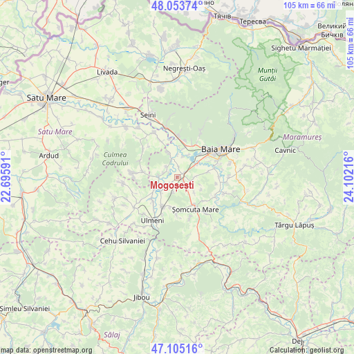
Mogoșești GPS coordinates[2]
47° 34' 53.76" North, 23° 23' 56.508" East
| Map corner | latitude | longitude |
|---|---|---|
| Upper-left | 48.05374°, | 22.69591° |
| Center: | 47.5816°, | 23.39903° |
| Lower-right: | 47.10516°, | 24.10216° |
| Map W x H: | 105.5×105.5 km | = 65.6×65.6mi |
| max Lat: | 48.23793° ⇑7.4% North |
| Mogoșești: | 47.5816° |
| min Lat: | ⇓92.6% South 43.65638° |
| min Long | Mogoșești | max Long |
| 20.31667° | 23.39903° | 29.65403° |
| W 21.4%⇐ | ⇒78.6% E |
Elevation
Elevation of Mogoșești is 156 m = 512 ft, and this is 98.9 m = 324 ft below average elevation for this country.
| Max E: |
1278 m = 4193 ft | 62.7% |
| Avg. | 254.9 m = 836 ft | |
| Mogoșești | 156 m = 512 ft | |
Min E: |
-2 m = -7 ft | 37.3% |
See also: Romania elevation on elevation.city.
Geographical zone
Mogoșești is located in North temperate zone (between Tropic of Cancer and the Arctic Circle). Distance of this North polar circle is 2110.6 km =1311.5 mi to North.| Distance of | km | miles | from Mogoșești |
|---|---|---|---|
| North Pole | 4716.5 | 2930.7 | to North |
| Arctic Circle | 2110.6 | 1311.5 | to North |
| Tropic Cancer | 2684.7 | 1668.2 | to South |
| Equator | 5290.6 | 3287.4 | to South |


Nearby cities:
15 places around Mogoșești: (largest is in red/bold)
• Ardusat
8 km =5 mi,  342°
342°
• Bozânta Mare
7.2 km =4.5 mi,  26°
26°
• Buzești
4.4 km =2.7 mi,  311°
311°
• Fersig
4.7 km =2.9 mi,  194°
194°
• Finteușu Mare
6.7 km =4.2 mi,  133°
133°
• Finteușu Mic
4.4 km =2.7 mi,  110°
110°
• Fărcaşa
4.9 km =3 mi,  272°
272°
• Gârdani
7.6 km =4.7 mi,  243°
243°
• Hideaga
2 km =1.2 mi,  58°
58°
• Lucăcești
6.6 km =4.1 mi,  225°
225°
• Lăpușel
7.3 km =4.5 mi, 55°
• Pribilești
2.7 km =1.7 mi, 226°
• Satulung
3.1 km =1.9 mi,  122°
122°
• Sârbi
4.4 km =2.7 mi,  288°
288°
• Tămaia
2.8 km =1.7 mi,  298°
298°
Sources, notices
• [Note1] Compared only with cities in Romania existing in our database
• [Src1] Map data: © OpenStreetMap contributors (CC-BY-SA)
• [Src2] Other city data from geonames.org with taken over terms of usage.
• [Src3] Geographical zone / Annual Mean Temperature by Robert A. Rohde @ Wikipedia
