Lancrăm geodata
Lancrăm (Alba) is a populated place; located in Romania in Europe/Bucharest (GMT+3) time zone. With population of 1,487 people, there are 3199 cities with bigger population in this country. Compared to other cities in Romania, 54.9% of cities are located further ↓South; 76.2% of cities are located further →East and 55% of cities have lower elevation than Lancrăm. Note1


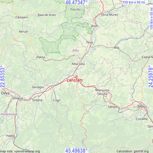
Lancrăm GPS coordinates[2]
45° 59' 13.488" North, 23° 33' 23.94" East
| Map corner | latitude | longitude |
|---|---|---|
| Upper-left | 46.47347°, | 22.85353° |
| Center: | 45.98708°, | 23.55665° |
| Lower-right: | 45.49638°, | 24.25978° |
| Map W x H: | 108.6×108.6 km | = 67.5×67.5mi |
| max Lat: | 48.23793° ⇑45.1% North |
| Lancrăm: | 45.98708° |
| min Lat: | ⇓54.9% South 43.65638° |
| min Long | Lancrăm | max Long |
| 20.31667° | 23.55665° | 29.65403° |
| W 23.8%⇐ | ⇒76.2% E |
Elevation
Elevation of Lancrăm is 238 m = 781 ft, and this is 16.9 m = 55 ft below average elevation for this country.
| Max E: |
1278 m = 4193 ft | 45% |
| Avg. | 254.9 m = 836 ft | |
| Lancrăm | 238 m = 781 ft | |
Min E: |
-2 m = -7 ft | 55% |
See also: Romania elevation on elevation.city.
Geographical zone
Lancrăm is located in North temperate zone (between Tropic of Cancer and the Arctic Circle). Distance of this North polar circle is 2287.9 km =1421.6 mi to North.| Distance of | km | miles | from Lancrăm |
|---|---|---|---|
| North Pole | 4893.8 | 3040.9 | to North |
| Arctic Circle | 2287.9 | 1421.6 | to North |
| Tropic Cancer | 2507.4 | 1558 | to South |
| Equator | 5113.3 | 3177.3 | to South |


Nearby cities:
15 places around Lancrăm: (largest is in red/bold)
• Alba Iulia
9.1 km =5.7 mi,  13°
13°
• Ciugud
8.4 km =5.2 mi,  33°
33°
• Cut
10 km =6.2 mi,  121°
121°
• Daia Română
9.1 km =5.7 mi,  68°
68°
• Oarda
5.2 km =3.2 mi, 8°
• Petrești
7.4 km =4.6 mi,  177°
177°
• Pianu de Jos
7.8 km =4.8 mi,  222°
222°
• Pâclișa
7.6 km =4.7 mi,  336°
336°
• Răhău
10.6 km =6.6 mi,  151°
151°
• Sebeş
3.6 km =2.2 mi,  161°
161°
• Sebeșel
11.1 km =6.9 mi, 176°
• Valea Vințului
8.5 km =5.3 mi,  293°
293°
• Vințu de Jos
5.5 km =3.4 mi,  278°
278°
• Vurpăr
7.1 km =4.4 mi, 281°
• Șeușa
9.8 km =6.1 mi, 34°
Sources, notices
• [Note1] Compared only with cities in Romania existing in our database
• [Src1] Map data: © OpenStreetMap contributors (CC-BY-SA)
• [Src2] Other city data from geonames.org with taken over terms of usage.
• [Src3] Geographical zone / Annual Mean Temperature by Robert A. Rohde @ Wikipedia
