Cut geodata
Cut (Alba) is a seat of a second-order administrative division; located in Romania in Europe/Bucharest (GMT+3) time zone. With population of 1,391 people, there are 3352 cities with bigger population in this country. Compared to other cities in Romania, 53.9% of cities are located further ↓South; 74.5% of cities are located further →East and 65% of cities have lower elevation than Cut. Note1


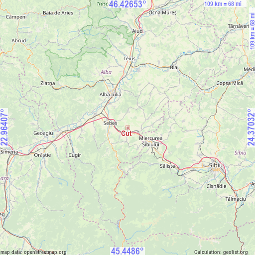
Cut GPS coordinates[2]
45° 56' 22.992" North, 23° 40' 1.884" East
| Map corner | latitude | longitude |
|---|---|---|
| Upper-left | 46.42653°, | 22.96407° |
| Center: | 45.93972°, | 23.66719° |
| Lower-right: | 45.4486°, | 24.37032° |
| Map W x H: | 108.7×108.7 km | = 67.5×67.5mi |
| max Lat: | 48.23793° ⇑46.1% North |
| Cut: | 45.93972° |
| min Lat: | ⇓53.9% South 43.65638° |
| min Long | Cut | max Long |
| 20.31667° | 23.66719° | 29.65403° |
| W 25.5%⇐ | ⇒74.5% E |
Elevation
Elevation of Cut is 290 m = 951 ft, and this is 35.1 m = 115 ft above average elevation for this country.
| Max E: |
1278 m = 4193 ft | 35% |
| Cut | 290 m 951 ft | |
| Avg. | 254.9 m = 836 ft | |
Min E: |
-2 m = -7 ft | 65% |
See also: Romania elevation on elevation.city.
Geographical zone
Cut is located in North temperate zone (between Tropic of Cancer and the Arctic Circle). Distance of this North polar circle is 2293.2 km =1424.9 mi to North.| Distance of | km | miles | from Cut |
|---|---|---|---|
| North Pole | 4899 | 3044.1 | to North |
| Arctic Circle | 2293.2 | 1424.9 | to North |
| Tropic Cancer | 2502.1 | 1554.7 | to South |
| Equator | 5108 | 3174 | to South |


Nearby cities:
15 places around Cut: (largest is in red/bold)
• Cunța
4.6 km =2.9 mi,  110°
110°
• Câlnic
6.3 km =3.9 mi,  180°
180°
• Daia Română
8.6 km =5.3 mi,  359°
359°
• Deal
9.5 km =5.9 mi,  198°
198°
• Drașov
5.9 km =3.7 mi,  91°
91°
• Ghirbom
11.4 km =7.1 mi,  22°
22°
• Gârbova
9.6 km =6 mi,  147°
147°
• Lancrăm
10 km =6.2 mi,  301°
301°
• Petrești
8.5 km =5.3 mi,  255°
255°
• Răhău
5.3 km =3.3 mi,  220°
220°
• Sebeş
7.7 km =4.8 mi,  284°
284°
• Sebeșel
9.7 km =6 mi,  233°
233°
• Săsciori
10.4 km =6.5 mi, 218°
• Vingard
10.2 km =6.3 mi,  37°
37°
• Şpring
9.5 km =5.9 mi,  71°
71°
Sources, notices
• [Note1] Compared only with cities in Romania existing in our database
• [Src1] Map data: © OpenStreetMap contributors (CC-BY-SA)
• [Src2] Other city data from geonames.org with taken over terms of usage.
• [Src3] Geographical zone / Annual Mean Temperature by Robert A. Rohde @ Wikipedia
