Alba Iulia geodata
Alba Iulia (Alba) is a seat of a first-order administrative division; located in Romania in Europe/Bucharest (GMT+3) time zone. With population of 66,085 people, there are 43 cities with bigger population in this country. Compared to other cities in Romania, 56.4% of cities are located further ↓South; 75.8% of cities are located further →East and 51.5% of cities have lower elevation than Alba Iulia. Note1


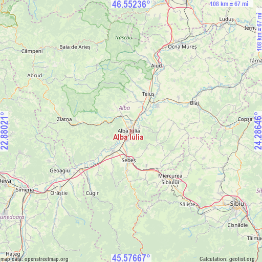
Alba Iulia GPS coordinates[2]
46° 4' 0.012" North, 23° 34' 59.988" East
| Map corner | latitude | longitude |
|---|---|---|
| Upper-left | 46.55236°, | 22.88021° |
| Center: | 46.06667°, | 23.58333° |
| Lower-right: | 45.57667°, | 24.28646° |
| Map W x H: | 108.5×108.5 km | = 67.4×67.4mi |
| max Lat: | 48.23793° ⇑43.6% North |
| Alba Iulia: | 46.06667° |
| min Lat: | ⇓56.4% South 43.65638° |
| min Long | Alba Iulia | max Long |
| 20.31667° | 23.58333° | 29.65403° |
| W 24.2%⇐ | ⇒75.8% E |
Elevation
Elevation of Alba Iulia is 219 m = 719 ft, and this is 35.9 m = 118 ft below average elevation for this country.
| Max E: |
1278 m = 4193 ft | 48.5% |
| Avg. | 254.9 m = 836 ft | |
| Alba Iulia | 219 m = 719 ft | |
Min E: |
-2 m = -7 ft | 51.5% |
See also: Alba Iulia elevation on elevation.city.
Geographical zone
Alba Iulia is located in North temperate zone (between Tropic of Cancer and the Arctic Circle). Distance of this North polar circle is 2279 km =1416.1 mi to North.| Distance of | km | miles | from Alba Iulia |
|---|---|---|---|
| North Pole | 4884.9 | 3035.3 | to North |
| Arctic Circle | 2279 | 1416.1 | to North |
| Tropic Cancer | 2516.2 | 1563.5 | to South |
| Equator | 5122.1 | 3182.7 | to South |


Nearby cities:
15 places around Alba Iulia: (largest is in red/bold)
• Bărăbanț
3.6 km =2.2 mi,  1°
1°
• Ciugud
3.2 km =2 mi,  125°
125°
• Daia Română
8.5 km =5.3 mi, 130°
• Ighiu
10.6 km =6.6 mi,  330°
330°
• Lancrăm
9.1 km =5.7 mi,  193°
193°
• Micești
4.4 km =2.7 mi, 331°
• Oarda
3.9 km =2.4 mi,  199°
199°
• Oiejdea
10.9 km =6.8 mi,  21°
21°
• Pâclișa
5.5 km =3.4 mi,  250°
250°
• Sântimbru
9 km =5.6 mi,  34°
34°
• Totoi
7.8 km =4.8 mi,  46°
46°
• Tăuți
9.5 km =5.9 mi,  290°
290°
• Vințu de Jos
11 km =6.8 mi,  223°
223°
• Șard
7.8 km =4.8 mi, 331°
• Șeușa
3.5 km =2.2 mi,  102°
102°
Sources, notices
• [Note1] Compared only with cities in Romania existing in our database
• [Src1] Map data: © OpenStreetMap contributors (CC-BY-SA)
• [Src2] Other city data from geonames.org with taken over terms of usage.
• [Src3] Geographical zone / Annual Mean Temperature by Robert A. Rohde @ Wikipedia
