Ciugud geodata
Ciugud (Alba) is a seat of a second-order administrative division; located in Romania in Europe/Bucharest (GMT+3) time zone. With population of 2,613 people, there are 2051 cities with bigger population in this country. Compared to other cities in Romania, 56% of cities are located further ↓South; 75.4% of cities are located further →East and 51.5% of cities have lower elevation than Ciugud. Note1


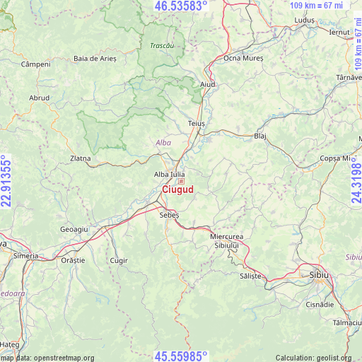
Ciugud GPS coordinates[2]
46° 3' 0" North, 23° 37' 0.012" East
| Map corner | latitude | longitude |
|---|---|---|
| Upper-left | 46.53583°, | 22.91355° |
| Center: | 46.05°, | 23.61667° |
| Lower-right: | 45.55985°, | 24.3198° |
| Map W x H: | 108.5×108.5 km | = 67.4×67.4mi |
| max Lat: | 48.23793° ⇑44% North |
| Ciugud: | 46.05° |
| min Lat: | ⇓56% South 43.65638° |
| min Long | Ciugud | max Long |
| 20.31667° | 23.61667° | 29.65403° |
| W 24.6%⇐ | ⇒75.4% E |
Elevation
Elevation of Ciugud is 219 m = 719 ft, and this is 35.9 m = 118 ft below average elevation for this country.
| Max E: |
1278 m = 4193 ft | 48.5% |
| Avg. | 254.9 m = 836 ft | |
| Ciugud | 219 m = 719 ft | |
Min E: |
-2 m = -7 ft | 51.5% |
See also: Romania elevation on elevation.city.
Geographical zone
Ciugud is located in North temperate zone (between Tropic of Cancer and the Arctic Circle). Distance of this North polar circle is 2280.9 km =1417.3 mi to North.| Distance of | km | miles | from Ciugud |
|---|---|---|---|
| North Pole | 4886.8 | 3036.5 | to North |
| Arctic Circle | 2280.9 | 1417.3 | to North |
| Tropic Cancer | 2514.4 | 1562.4 | to South |
| Equator | 5120.3 | 3181.6 | to South |


Nearby cities:
15 places around Ciugud: (largest is in red/bold)
• Alba Iulia
3.2 km =2 mi,  305°
305°
• Berghin
9.8 km =6.1 mi,  71°
71°
• Bărăbanț
6 km =3.7 mi,  335°
335°
• Daia Română
5.4 km =3.4 mi,  133°
133°
• Ghirbom
8.4 km =5.2 mi,  101°
101°
• Henig
10.8 km =6.7 mi,  54°
54°
• Lancrăm
8.4 km =5.2 mi,  213°
213°
• Micești
7.4 km =4.6 mi,  320°
320°
• Oarda
4.3 km =2.7 mi,  244°
244°
• Pâclișa
7.7 km =4.8 mi,  270°
270°
• Sântimbru
9.6 km =6 mi,  15°
15°
• Totoi
7.9 km =4.9 mi, 23°
• Vingard
10.9 km =6.8 mi,  112°
112°
• Șard
10.7 km =6.6 mi, 324°
• Șeușa
1.4 km =0.9 mi,  38°
38°
Sources, notices
• [Note1] Compared only with cities in Romania existing in our database
• [Src1] Map data: © OpenStreetMap contributors (CC-BY-SA)
• [Src2] Other city data from geonames.org with taken over terms of usage.
• [Src3] Geographical zone / Annual Mean Temperature by Robert A. Rohde @ Wikipedia
