Jabenița geodata
Jabenița (Mureş) is a populated place; located in Romania in Europe/Bucharest (GMT+3) time zone. With population of 1,128 people, there are 3912 cities with bigger population in this country. Compared to other cities in Romania, 73.8% of cities are located further ↓South; 55.5% of cities are located further →East and 80.1% of cities have lower elevation than Jabenița. Note1


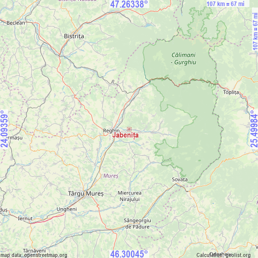
Jabenița GPS coordinates[2]
46° 47' 2.652" North, 24° 47' 48.156" East
| Map corner | latitude | longitude |
|---|---|---|
| Upper-left | 47.26338°, | 24.09359° |
| Center: | 46.78407°, | 24.79671° |
| Lower-right: | 46.30045°, | 25.49984° |
| Map W x H: | 107.1×107.1 km | = 66.5×66.5mi |
| max Lat: | 48.23793° ⇑26.2% North |
| Jabenița: | 46.78407° |
| min Lat: | ⇓73.8% South 43.65638° |
| min Long | Jabenița | max Long |
| 20.31667° | 24.79671° | 29.65403° |
| W 44.5%⇐ | ⇒55.5% E |
Elevation
Elevation of Jabenița is 394 m = 1293 ft, and this is 139.1 m = 456 ft above average elevation for this country.
| Max E: |
1278 m = 4193 ft | 19.9% |
| Jabenița | 394 m 1293 ft | |
| Avg. | 254.9 m = 836 ft | |
Min E: |
-2 m = -7 ft | 80.1% |
See also: Romania elevation on elevation.city.
Geographical zone
Jabenița is located in North temperate zone (between Tropic of Cancer and the Arctic Circle). Distance of this North polar circle is 2199.3 km =1366.6 mi to North.| Distance of | km | miles | from Jabenița |
|---|---|---|---|
| North Pole | 4805.2 | 2985.8 | to North |
| Arctic Circle | 2199.3 | 1366.6 | to North |
| Tropic Cancer | 2596 | 1613.1 | to South |
| Equator | 5201.9 | 3232.3 | to South |


Nearby cities:
15 places around Jabenița: (largest is in red/bold)
• Apalina
8.6 km =5.3 mi,  245°
245°
• Beica de Jos
5.6 km =3.5 mi,  177°
177°
• Brâncoveneşti
8.5 km =5.3 mi,  340°
340°
• Cașva
6.7 km =4.2 mi,  89°
89°
• Gurghiu
4.5 km =2.8 mi,  115°
115°
• Hodac
9.3 km =5.8 mi,  101°
101°
• Ideciu de Jos
4 km =2.5 mi,  296°
296°
• Iernuțeni
6.3 km =3.9 mi, 249°
• Luieriu
9.5 km =5.9 mi,  320°
320°
• Orșova
9.7 km =6 mi,  113°
113°
• Petelea
9.2 km =5.7 mi,  228°
228°
• Reghin
7.3 km =4.5 mi,  261°
261°
• Reghin-Sat
6.1 km =3.8 mi,  269°
269°
• Solovăstru
3 km =1.9 mi, 229°
• Suseni
5.9 km =3.7 mi, 303°
Sources, notices
• [Note1] Compared only with cities in Romania existing in our database
• [Src1] Map data: © OpenStreetMap contributors (CC-BY-SA)
• [Src2] Other city data from geonames.org with taken over terms of usage.
• [Src3] Geographical zone / Annual Mean Temperature by Robert A. Rohde @ Wikipedia
