Gurghiu geodata
Gurghiu (Mureş) is a seat of a second-order administrative division; located in Romania in Europe/Bucharest (GMT+3) time zone. With population of 6,277 people, there are 496 cities with bigger population in this country. Compared to other cities in Romania, 73.2% of cities are located further ↓South; 54.8% of cities are located further →East and 82.4% of cities have lower elevation than Gurghiu. Note1


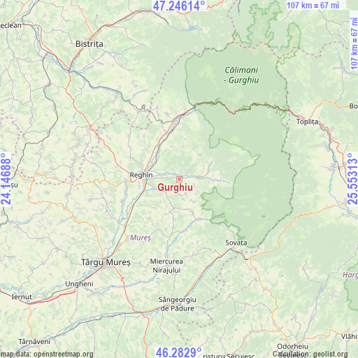
Gurghiu GPS coordinates[2]
46° 46' 0.012" North, 24° 51' 0" East
| Map corner | latitude | longitude |
|---|---|---|
| Upper-left | 47.24614°, | 24.14688° |
| Center: | 46.76667°, | 24.85° |
| Lower-right: | 46.2829°, | 25.55313° |
| Map W x H: | 107.1×107.1 km | = 66.5×66.5mi |
| max Lat: | 48.23793° ⇑26.8% North |
| Gurghiu: | 46.76667° |
| min Lat: | ⇓73.2% South 43.65638° |
| min Long | Gurghiu | max Long |
| 20.31667° | 24.85° | 29.65403° |
| W 45.2%⇐ | ⇒54.8% E |
Elevation
Elevation of Gurghiu is 417 m = 1368 ft, and this is 162.1 m = 532 ft above average elevation for this country.
| Max E: |
1278 m = 4193 ft | 17.6% |
| Gurghiu | 417 m 1368 ft | |
| Avg. | 254.9 m = 836 ft | |
Min E: |
-2 m = -7 ft | 82.4% |
See also: Romania elevation on elevation.city.
Geographical zone
Gurghiu is located in North temperate zone (between Tropic of Cancer and the Arctic Circle). Distance of this North polar circle is 2201.2 km =1367.8 mi to North.| Distance of | km | miles | from Gurghiu |
|---|---|---|---|
| North Pole | 4807.1 | 2987 | to North |
| Arctic Circle | 2201.2 | 1367.8 | to North |
| Tropic Cancer | 2594 | 1611.8 | to South |
| Equator | 5200 | 3231.1 | to South |


Nearby cities:
15 places around Gurghiu: (largest is in red/bold)
• Beica de Jos
5.3 km =3.3 mi,  225°
225°
• Cașva
3.3 km =2.1 mi,  53°
53°
• Chiheru de Jos
9.6 km =6 mi,  164°
164°
• Hodac
5.1 km =3.2 mi,  90°
90°
• Ibăneşti
6.3 km =3.9 mi, 90°
• Ibănești-Pădure
10.5 km =6.5 mi, 94°
• Ideciu de Jos
8.5 km =5.3 mi,  295°
295°
• Iernuțeni
10 km =6.2 mi,  268°
268°
• Jabenița
4.5 km =2.8 mi, 295°
• Orșova
5.2 km =3.2 mi,  110°
110°
• Reghin-Sat
10.3 km =6.4 mi,  280°
280°
• Solovăstru
6.3 km =3.9 mi, 270°
• Suseni
10.4 km =6.5 mi, 300°
• Toaca
9.4 km =5.8 mi,  67°
67°
• Urisiu de Sus
8.2 km =5.1 mi,  145°
145°
Sources, notices
• [Note1] Compared only with cities in Romania existing in our database
• [Src1] Map data: © OpenStreetMap contributors (CC-BY-SA)
• [Src2] Other city data from geonames.org with taken over terms of usage.
• [Src3] Geographical zone / Annual Mean Temperature by Robert A. Rohde @ Wikipedia
