Izvoarele geodata
Izvoarele (Giurgiu) is a seat of a second-order administrative division; located in Romania in Europe/Bucharest (GMT+3) time zone. With population of 1,489 people, there are 3195 cities with bigger population in this country. Compared to other cities in Romania, 94% of cities are located further ↑North; 69.1% of cities are located further ←West and 93.5% of cities have higher elevation than Izvoarele. Note1


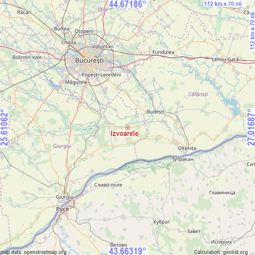
Izvoarele GPS coordinates[2]
44° 10' 10.848" North, 26° 18' 49.464" East
| Map corner | latitude | longitude |
|---|---|---|
| Upper-left | 44.67186°, | 25.61062° |
| Center: | 44.16968°, | 26.31374° |
| Lower-right: | 43.66319°, | 27.01687° |
| Map W x H: | 112.2×112.2 km | = 69.7×69.7mi |
| max Lat: | 48.23793° ⇑94% North |
| Izvoarele: | 44.16968° |
| min Lat: | ⇓6% South 43.65638° |
| min Long | Izvoarele | max Long |
| 20.31667° | 26.31374° | 29.65403° |
| W 69.1%⇐ | ⇒30.9% E |
Elevation
Elevation of Izvoarele is 41 m = 135 ft, and this is 213.9 m = 702 ft below average elevation for this country.
| Max E: |
1278 m = 4193 ft | 93.5% |
| Avg. | 254.9 m = 836 ft | |
| Izvoarele | 41 m = 135 ft | |
Min E: |
-2 m = -7 ft | 6.5% |
See also: Romania elevation on elevation.city.
Geographical zone
Izvoarele is located in North temperate zone (between Tropic of Cancer and the Arctic Circle). Distance of this Northern Tropic circle is 2305.3 km =1432.4 mi to South.| Distance of | km | miles | from Izvoarele |
|---|---|---|---|
| North Pole | 5095.9 | 3166.4 | to North |
| Arctic Circle | 2490 | 1547.2 | to North |
| Tropic Cancer | 2305.3 | 1432.4 | to South |
| Equator | 4911.2 | 3051.7 | to South |


Nearby cities:
15 places around Izvoarele: (largest is in red/bold)
• Colibaşi
10.2 km =6.3 mi,  290°
290°
• Crivăț
10.3 km =6.4 mi,  75°
75°
• Câmpurelu
12.4 km =7.7 mi,  305°
305°
• Dobreni
12.3 km =7.6 mi,  319°
319°
• Falaștoaca
10.6 km =6.6 mi,  282°
282°
• Gostinari
7.1 km =4.4 mi, 285°
• Goştinari-Văcăreşti
7.9 km =4.9 mi, 281°
• Greaca
7 km =4.3 mi,  162°
162°
• Gruiu
10.9 km =6.8 mi,  49°
49°
• Herăști
5.9 km =3.7 mi,  37°
37°
• Hotarele
4.5 km =2.8 mi,  86°
86°
• Mironești
5.3 km =3.3 mi,  269°
269°
• Prundu
10.8 km =6.7 mi,  219°
219°
• Valea Dragului
4.8 km =3 mi,  350°
350°
• Vărăşti
9.2 km =5.7 mi,  325°
325°
Sources, notices
• [Note1] Compared only with cities in Romania existing in our database
• [Src1] Map data: © OpenStreetMap contributors (CC-BY-SA)
• [Src2] Other city data from geonames.org with taken over terms of usage.
• [Src3] Geographical zone / Annual Mean Temperature by Robert A. Rohde @ Wikipedia
