Iveşti geodata
Iveşti (Vaslui) is a seat of a second-order administrative division; located in Romania in Europe/Bucharest (GMT+3) time zone. With population of 4,631 people, there are 907 cities with bigger population in this country. Compared to other cities in Romania, 59.1% of cities are located further ↓South; 91.3% of cities are located further ←West and 86.8% of cities have higher elevation than Iveşti. Note1


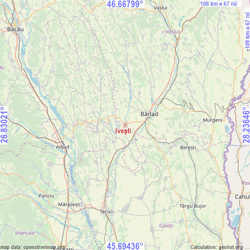
Iveşti GPS coordinates[2]
46° 10' 59.988" North, 27° 31' 59.988" East
| Map corner | latitude | longitude |
|---|---|---|
| Upper-left | 46.66799°, | 26.83021° |
| Center: | 46.18333°, | 27.53333° |
| Lower-right: | 45.69436°, | 28.23646° |
| Map W x H: | 108.3×108.3 km | = 67.3×67.3mi |
| max Lat: | 48.23793° ⇑40.9% North |
| Iveşti: | 46.18333° |
| min Lat: | ⇓59.1% South 43.65638° |
| min Long | Iveşti | max Long |
| 20.31667° | 27.53333° | 29.65403° |
| W 91.3%⇐ | ⇒8.7% E |
Elevation
Elevation of Iveşti is 72 m = 236 ft, and this is 182.9 m = 600 ft below average elevation for this country.
| Max E: |
1278 m = 4193 ft | 86.8% |
| Avg. | 254.9 m = 836 ft | |
| Iveşti | 72 m = 236 ft | |
Min E: |
-2 m = -7 ft | 13.2% |
See also: Romania elevation on elevation.city.
Geographical zone
Iveşti is located in North temperate zone (between Tropic of Cancer and the Arctic Circle). Distance of this North polar circle is 2266.1 km =1408.1 mi to North.| Distance of | km | miles | from Iveşti |
|---|---|---|---|
| North Pole | 4872 | 3027.3 | to North |
| Arctic Circle | 2266.1 | 1408.1 | to North |
| Tropic Cancer | 2529.2 | 1571.6 | to South |
| Equator | 5135.1 | 3190.8 | to South |


Nearby cities:
15 places around Iveşti: (largest is in red/bold)
• Bogheşti
10.4 km =6.5 mi,  259°
259°
• Bârlad
11.8 km =7.3 mi,  62°
62°
• Bădeana
5.3 km =3.3 mi,  133°
133°
• Ciocani
8.8 km =5.5 mi,  13°
13°
• Ciorăști
9.9 km =6.2 mi,  218°
218°
• Ciureștii Noi
12.3 km =7.6 mi,  138°
138°
• Coroieşti
8.4 km =5.2 mi,  332°
332°
• Căbești
7.8 km =4.8 mi,  293°
293°
• Gefu
12.1 km =7.5 mi,  186°
186°
• Griviţa
9.7 km =6 mi,  112°
112°
• Podu Turcului
11.7 km =7.3 mi,  279°
279°
• Pogonești
3.5 km =2.2 mi,  181°
181°
• Poiana
13.2 km =8.2 mi,  320°
320°
• Trestiana
9.2 km =5.7 mi,  78°
78°
• Tutova
7.5 km =4.7 mi,  170°
170°
Sources, notices
• [Note1] Compared only with cities in Romania existing in our database
• [Src1] Map data: © OpenStreetMap contributors (CC-BY-SA)
• [Src2] Other city data from geonames.org with taken over terms of usage.
• [Src3] Geographical zone / Annual Mean Temperature by Robert A. Rohde @ Wikipedia
