Ciorăști geodata
Ciorăști (Galaţi) is a populated place; located in Romania in Europe/Bucharest (GMT+3) time zone. With population of 1,186 people, there are 3781 cities with bigger population in this country. Compared to other cities in Romania, 57.7% of cities are located further ↓South; 90.3% of cities are located further ←West and 75.4% of cities have higher elevation than Ciorăști. Note1


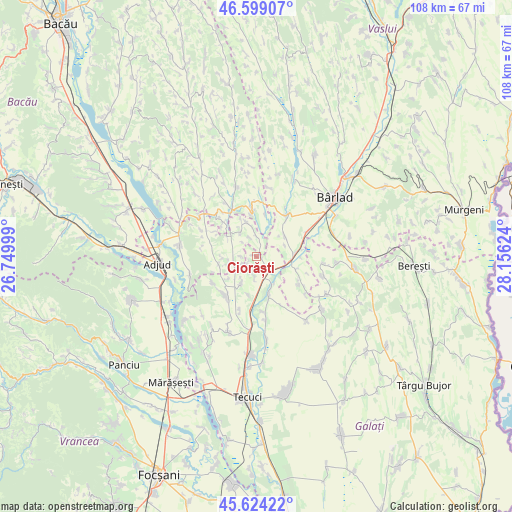
Ciorăști GPS coordinates[2]
46° 6' 49.68" North, 27° 27' 11.196" East
| Map corner | latitude | longitude |
|---|---|---|
| Upper-left | 46.59907°, | 26.74999° |
| Center: | 46.1138°, | 27.45311° |
| Lower-right: | 45.62422°, | 28.15624° |
| Map W x H: | 108.4×108.4 km | = 67.4×67.4mi |
| max Lat: | 48.23793° ⇑42.3% North |
| Ciorăști: | 46.1138° |
| min Lat: | ⇓57.7% South 43.65638° |
| min Long | Ciorăști | max Long |
| 20.31667° | 27.45311° | 29.65403° |
| W 90.3%⇐ | ⇒9.7% E |
Elevation
Elevation of Ciorăști is 109 m = 358 ft, and this is 145.9 m = 479 ft below average elevation for this country.
| Max E: |
1278 m = 4193 ft | 75.4% |
| Avg. | 254.9 m = 836 ft | |
| Ciorăști | 109 m = 358 ft | |
Min E: |
-2 m = -7 ft | 24.6% |
See also: Romania elevation on elevation.city.
Geographical zone
Ciorăști is located in North temperate zone (between Tropic of Cancer and the Arctic Circle). Distance of this North polar circle is 2273.8 km =1412.9 mi to North.| Distance of | km | miles | from Ciorăști |
|---|---|---|---|
| North Pole | 4879.7 | 3032.1 | to North |
| Arctic Circle | 2273.8 | 1412.9 | to North |
| Tropic Cancer | 2521.5 | 1566.8 | to South |
| Equator | 5127.4 | 3186 | to South |


Nearby cities:
15 places around Ciorăști: (largest is in red/bold)
• Bogheşti
7.2 km =4.5 mi,  325°
325°
• Brăhăşeştii de Sus
10.7 km =6.6 mi,  228°
228°
• Bădeana
10.8 km =6.7 mi,  68°
68°
• Căbești
10.9 km =6.8 mi,  354°
354°
• Gefu
6.5 km =4 mi,  131°
131°
• Ghidigeni
8 km =5 mi,  152°
152°
• Gohor
6.7 km =4.2 mi,  218°
218°
• Iveşti
9.9 km =6.2 mi,  38°
38°
• Podu Turcului
11 km =6.8 mi, 330°
• Pogonești
7.4 km =4.6 mi,  54°
54°
• Priponeşti
3.7 km =2.3 mi,  204°
204°
• Sălceni
10.5 km =6.5 mi,  121°
121°
• Toflea
10.7 km =6.6 mi,  238°
238°
• Tutova
7.5 km =4.7 mi,  87°
87°
• Tănăsoaia
6.8 km =4.2 mi,  257°
257°
Sources, notices
• [Note1] Compared only with cities in Romania existing in our database
• [Src1] Map data: © OpenStreetMap contributors (CC-BY-SA)
• [Src2] Other city data from geonames.org with taken over terms of usage.
• [Src3] Geographical zone / Annual Mean Temperature by Robert A. Rohde @ Wikipedia
