Ivăneasa geodata
Ivăneasa (Bistriţa-Năsăud) is a populated place; located in Romania in Europe/Bucharest (GMT+3) time zone. With population of 609 people, there are 6139 cities with bigger population in this country. Compared to other cities in Romania, 87.4% of cities are located further ↓South; 53.9% of cities are located further →East and 97.9% of cities have lower elevation than Ivăneasa. Note1


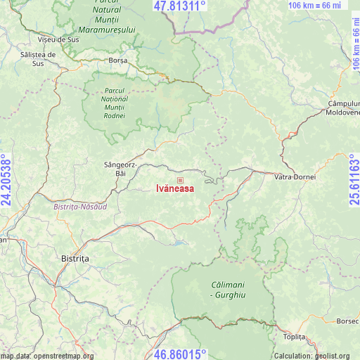
Ivăneasa GPS coordinates[2]
47° 20' 19.608" North, 24° 54' 30.6" East
| Map corner | latitude | longitude |
|---|---|---|
| Upper-left | 47.81311°, | 24.20538° |
| Center: | 47.33878°, | 24.9085° |
| Lower-right: | 46.86015°, | 25.61163° |
| Map W x H: | 106×106 km | = 65.9×65.9mi |
| max Lat: | 48.23793° ⇑12.6% North |
| Ivăneasa: | 47.33878° |
| min Lat: | ⇓87.4% South 43.65638° |
| min Long | Ivăneasa | max Long |
| 20.31667° | 24.9085° | 29.65403° |
| W 46.1%⇐ | ⇒53.9% E |
Elevation
Elevation of Ivăneasa is 765 m = 2510 ft, and this is 510.1 m = 1674 ft above average elevation for this country.
| Max E: |
1278 m = 4193 ft | 2.1% |
| Ivăneasa | 765 m 2510 ft | |
| Avg. | 254.9 m = 836 ft | |
Min E: |
-2 m = -7 ft | 97.9% |
See also: Romania elevation on elevation.city.
Geographical zone
Ivăneasa is located in North temperate zone (between Tropic of Cancer and the Arctic Circle). Distance of this North polar circle is 2137.6 km =1328.2 mi to North.| Distance of | km | miles | from Ivăneasa |
|---|---|---|---|
| North Pole | 4743.5 | 2947.5 | to North |
| Arctic Circle | 2137.6 | 1328.2 | to North |
| Tropic Cancer | 2657.7 | 1651.4 | to South |
| Equator | 5263.6 | 3270.6 | to South |


Nearby cities:
15 places around Ivăneasa: (largest is in red/bold)
• Anieș
13.4 km =8.3 mi,  308°
308°
• Arșița
6 km =3.7 mi,  292°
292°
• Cormaia
17.2 km =10.7 mi,  280°
280°
• Ilva Mare
3.2 km =2 mi,  348°
348°
• Leşu
12.2 km =7.6 mi,  258°
258°
• Lunca Ilvei
6.4 km =4 mi,  61°
61°
• Lunca Leșului
10.5 km =6.5 mi,  251°
251°
• Măgura Ilvei
9.6 km =6 mi,  301°
301°
• Măieru
13.7 km =8.5 mi, 299°
• Poiana Ilvei
12.8 km =8 mi, 279°
• Poiana Stampei
17.1 km =10.6 mi,  98°
98°
• Rodna
11.1 km =6.9 mi,  321°
321°
• Tiha Bârgăului
15.9 km =9.9 mi,  222°
222°
• Tureac
14.4 km =8.9 mi,  212°
212°
• Șanț
12.4 km =7.7 mi,  357°
357°
Sources, notices
• [Note1] Compared only with cities in Romania existing in our database
• [Src1] Map data: © OpenStreetMap contributors (CC-BY-SA)
• [Src2] Other city data from geonames.org with taken over terms of usage.
• [Src3] Geographical zone / Annual Mean Temperature by Robert A. Rohde @ Wikipedia
