Arșița geodata
Arșița (Bistriţa-Năsăud) is a populated place; located in Romania in Europe/Bucharest (GMT+3) time zone. With population of 521 people, there are 6851 cities with bigger population in this country. Compared to other cities in Romania, 88% of cities are located further ↓South; 54.9% of cities are located further →East and 97.1% of cities have lower elevation than Arșița. Note1


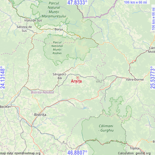
Arșița GPS coordinates[2]
47° 21' 32.94" North, 24° 50' 4.56" East
| Map corner | latitude | longitude |
|---|---|---|
| Upper-left | 47.8333°, | 24.13148° |
| Center: | 47.35915°, | 24.8346° |
| Lower-right: | 46.8807°, | 25.53773° |
| Map W x H: | 105.9×105.9 km | = 65.8×65.8mi |
| max Lat: | 48.23793° ⇑12% North |
| Arșița: | 47.35915° |
| min Lat: | ⇓88% South 43.65638° |
| min Long | Arșița | max Long |
| 20.31667° | 24.8346° | 29.65403° |
| W 45.1%⇐ | ⇒54.9% E |
Elevation
Elevation of Arșița is 724 m = 2375 ft, and this is 469.1 m = 1539 ft above average elevation for this country.
| Max E: |
1278 m = 4193 ft | 2.9% |
| Arșița | 724 m 2375 ft | |
| Avg. | 254.9 m = 836 ft | |
Min E: |
-2 m = -7 ft | 97.1% |
See also: Romania elevation on elevation.city.
Geographical zone
Arșița is located in North temperate zone (between Tropic of Cancer and the Arctic Circle). Distance of this North polar circle is 2135.3 km =1326.8 mi to North.| Distance of | km | miles | from Arșița |
|---|---|---|---|
| North Pole | 4741.2 | 2946 | to North |
| Arctic Circle | 2135.3 | 1326.8 | to North |
| Tropic Cancer | 2659.9 | 1652.8 | to South |
| Equator | 5265.8 | 3272 | to South |


Nearby cities:
15 places around Arșița: (largest is in red/bold)
• Anieș
7.8 km =4.8 mi,  320°
320°
• Cormaia
11.4 km =7.1 mi,  274°
274°
• Ilva Mare
5 km =3.1 mi,  80°
80°
• Ilva Mică
13.5 km =8.4 mi,  249°
249°
• Ivăneasa
6 km =3.7 mi,  112°
112°
• Leşu
7.9 km =4.9 mi,  233°
233°
• Lunca Ilvei
11.2 km =7 mi,  85°
85°
• Lunca Leșului
7.1 km =4.4 mi,  218°
218°
• Măgura Ilvei
3.7 km =2.3 mi, 315°
• Măieru
7.8 km =4.8 mi,  305°
305°
• Poiana Ilvei
7 km =4.3 mi, 268°
• Rodna
6.5 km =4 mi,  348°
348°
• Sângeorz-Băi
12.3 km =7.6 mi, 274°
• Valea Borcutului
13.8 km =8.6 mi,  277°
277°
• Șanț
11.2 km =7 mi,  25°
25°
Sources, notices
• [Note1] Compared only with cities in Romania existing in our database
• [Src1] Map data: © OpenStreetMap contributors (CC-BY-SA)
• [Src2] Other city data from geonames.org with taken over terms of usage.
• [Src3] Geographical zone / Annual Mean Temperature by Robert A. Rohde @ Wikipedia
