Ivanda geodata
Ivanda (Timiş) is a populated place; located in Romania in Europe/Bucharest (GMT+3) time zone. With population of 539 people, there are 6689 cities with bigger population in this country. Compared to other cities in Romania, 54.1% of cities are located further ↑North; 99.4% of cities are located further →East and 85.7% of cities have higher elevation than Ivanda. Note1


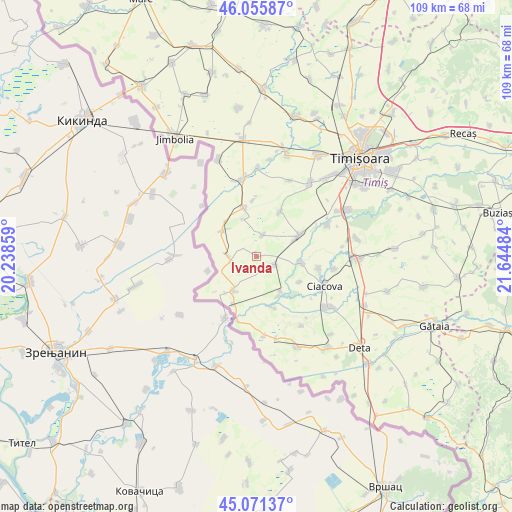
Ivanda GPS coordinates[2]
45° 33' 56.808" North, 20° 56' 30.156" East
| Map corner | latitude | longitude |
|---|---|---|
| Upper-left | 46.05587°, | 20.23859° |
| Center: | 45.56578°, | 20.94171° |
| Lower-right: | 45.07137°, | 21.64484° |
| Map W x H: | 109.5×109.5 km | = 68×68mi |
| max Lat: | 48.23793° ⇑54.1% North |
| Ivanda: | 45.56578° |
| min Lat: | ⇓45.9% South 43.65638° |
| min Long | Ivanda | max Long |
| 20.31667° | 20.94171° | 29.65403° |
| W 0.6%⇐ | ⇒99.4% E |
Elevation
Elevation of Ivanda is 76 m = 249 ft, and this is 178.9 m = 587 ft below average elevation for this country.
| Max E: |
1278 m = 4193 ft | 85.7% |
| Avg. | 254.9 m = 836 ft | |
| Ivanda | 76 m = 249 ft | |
Min E: |
-2 m = -7 ft | 14.3% |
See also: Romania elevation on elevation.city.
Geographical zone
Ivanda is located in North temperate zone (between Tropic of Cancer and the Arctic Circle). Distance of this North polar circle is 2334.7 km =1450.7 mi to North.| Distance of | km | miles | from Ivanda |
|---|---|---|---|
| North Pole | 4940.6 | 3069.9 | to North |
| Arctic Circle | 2334.7 | 1450.7 | to North |
| Tropic Cancer | 2460.5 | 1528.9 | to South |
| Equator | 5066.4 | 3148.1 | to South |


Nearby cities:
15 places around Ivanda: (largest is in red/bold)
• Cebza
9.8 km =6.1 mi,  98°
98°
• Ciacova
15.9 km =9.9 mi,  113°
113°
• Crai Nou
9.8 km =6.1 mi,  152°
152°
• Diniaș
10.7 km =6.6 mi,  27°
27°
• Foeni
9.1 km =5.7 mi,  214°
214°
• Giulvăz
3.8 km =2.4 mi,  119°
119°
• Iohanisfeld
6.1 km =3.8 mi,  271°
271°
• Otelec
9 km =5.6 mi,  307°
307°
• Peciu Nou
10.1 km =6.3 mi,  63°
63°
• Petroman
13.7 km =8.5 mi, 101°
• Pustiniș
10 km =6.2 mi,  319°
319°
• Rudna
9.1 km =5.7 mi, 145°
• Răuți
12 km =7.5 mi,  356°
356°
• Sânmartinu Sârbesc
4.6 km =2.9 mi,  16°
16°
• Uivar
10.6 km =6.6 mi,  344°
344°
Sources, notices
• [Note1] Compared only with cities in Romania existing in our database
• [Src1] Map data: © OpenStreetMap contributors (CC-BY-SA)
• [Src2] Other city data from geonames.org with taken over terms of usage.
• [Src3] Geographical zone / Annual Mean Temperature by Robert A. Rohde @ Wikipedia
